Search This Blog

Saturday, October 8, 2022

10/8/22 Report - Multibeam Sonar Project Locates Hundreds of Shipwrecks. Ancient Stone Spheres Found. More On Predicting Erosion.


Written by the TreasureGuide for the exclusive use of the Treasure Beaches Report.

Predicted Path for Julia.
Source: nhc.noaa.gov.

There is a storm out there that is supposed to become a hurricane, but as you can see above, it is snot coming our way.

---

Using state-of-the art multibeam sonar, researchers at Bangor University have finally been able to positively identify the wreck and have revealed her position for the first time. 

For the marine archaeologist, multibeam sonar has the potential to be as impactful as the use of aerial photography was for landscape archaeology. Multibeam sonar enables seabed mapping of such detail that superstructure details can be revealed on the sonar images.

The SS Mesaba was one among 273 shipwrecks lying in 7500 square miles of Irish Sea, which were scanned and cross-referenced against the UK Hydrographic Office’s database of wrecks and other sources. 

It was thought that 101 wrecks were unidentified, but the number of newly identified wrecks was far higher, as many, the SS Mesaba included, had been wrongly identified in the past...

Here is the link for the rest of that article.

Finding the ship that sent out a warning to The Titanic | Bangor University

---


Archaeologists from the University of Bristol have suggested that mysterious stone spheres found at various ancient settlements across the Aegean and Mediterranean could be playing pieces from one of the earliest ever board games.

There has been quite a lot of speculation around these spheres found at sites on Santorini, Crete, Cyprus, and other Greek Islands with theories around their use including being for some sort of sling stones, tossing balls, counting/record-keeping system or as counters/pawns.

Previous research by the same team from the University of Bristol indicated that there was variability in sphere size within specific clusters and collections of spheres. Following on from this the team wanted to explore potential patterning within these sphere concentrations, to help give an insight into their potential use...

Here is the link for that article.


This article is about stone spheres, but it has much broader implications. It is about how people assess information and derive conclusions.  Spheres are very simple, and, therefore, common shapes.  One definition defines a sphere as a round solid figure, or its surface, with every point on its surface equidistant from its center.  If you stick to the definition and measure very precisely, you'll find fewer spheres. For example. is a golf ball a sphere. In general shape, maybe yes, but if you don't ignore the indentations, a golf ball is not a sphere. It depends to some extent about how precise you attempt to be.  Very often we ignore deviations, such as those on the golf ball, and consider it to be spherical or round.  Some people tend to be more exacting than others in the way they look at and think about the world.

The objects in this article are referred to as spheres, but they probably are spheres only in a general sense.  They could be used as weapons or projectiles, for hunting or keeping records, or other uses.  When an object does not have an obvious use, archaeologists often seem to use use the category of gaming pieces or religious objects.   I'm think those categories are used too often for unidentified objects.  It would seem to me there are many other possibilities.

---

Not too long ago - it was just before the big south wind and recent beach erosion - I did a post on predicting beach erosion.  People always talk about the water and factors such as the size of the surf and the tides, but they often ignore the shape and characteristics of the beach.

Beaches aren't straight lines and they don't run exactly north to south.  They are curved and the general direction of most Treasure Coast beaches is a little northwest to southeast, and there are a lot of bends or curves.  That means that an east swell will not be hitting the beach at a 90 degree angle. A slight northeast swell will hit much of the Treasure Coast at a 90 degree angle, but the angle will vary with the curves of the shoreline.  Areas that face more north will tend to erode at different times than those areas where the shoreline faces more south.  

The recent south wind that caused erosion most everywhere along the Treasure Coast almost parallel to the beach and was at an oblique angle to most of the beaches and was not affected much by slight curves or deviations in the angle of the shoreline.

Another factor that is often overlooked, is the amount of sand in front of the beach and other submerged features such as reefs or rocks that will affect how the water force hits the beach.

---

Source: MagicSeaWeed.com.

The tides are still high, but the surf is back to very small.

Good hunting,

TreasureGuide@comcast.net

Thursday, October 6, 2022

10/6/22 Report - Some Treasure Coast Finds From After Ian. Recent Treasure Coast Beach Photos.


Written by the TreasureGuide for the exclusive use of the Treasure Beaches Report.


TM  sent me the following email mesage along with these four find photos.


Just want to show a few of the things I found since the storm.

The ring was found the day after Ian north of the museum and south of Sebastian inlet about halfway between.

The quarter size coin with the cross was found South of McLarty museum. The other side is worn and I can’t make much out on it. It is quarter size and I’m still trying to identify when it was minted.

The large coin is a Nathan Hale Commemorative coin found at Wabasso beach
As was the small cross.

Any thoughts you might have are appreciated.


TM didn't tell where the cross medallion was found but the other finds are shown below.


Interesting finds TM.  I hope to look at them better and maybe have some comments some other time.  I don't have time today.


---


Below are some beach photos taken Wednesday by Joe D.


I hope you recognize the beaches.  I was having a lot of trouble getting photos posted today.  I didn't think I'd post anything today, but found a way around the problem, si I'll have to settle with what I managed to get done.

Thanks to Joe D. for the beach photos.

Good hunting,

TreasureGuide@comcast.net


Wednesday, October 5, 2022

10/5/22 Report - Treasure Box Found in Martin County. Increased North Wind and Surf and Looking Ahead.


Written by the Treasureguide for the exclusive use of the Treasure Beaches Report.


MARTIN COUNTY — It took about 1½ years for someone to discover the first treasure they buried. 

After two years of burying treasures for Florida beachgoers to find, a family learned their third chest was pulled out of the water within a little more than a month — thanks to Hurricane Ian's ocean tides.

Joe Jansen, of St. Charles, Missouri, said he and his family buried the treasure in front of a vacation rental home 2 miles south of Jensen Beach Park.

It was a surprise the ocean swept it away.

"... We put it in there with a note, and expected someone would find it sooner or later, but we never expected that it would be washed away ... It was pretty far up the beach and well above high tide," Jansen said. "Apparently they had enough storm surge there that it came out from the sand."


Here is the link for the rest of that story.

https://www.tcpalm.com/story/weather/hurricanes/2022/10/03/missouri-family-shares-treasure-tradition-after-chest-found-jensen-beach-florida/8134876001/ 


Tbanks to Rick B. and DJ for senting that link.

---

As of Tuesday, Seagrape Trail, Turtle Trail and Tracking Statin beaches were still closed.

Indian River and St. Lucie counties are already trying to get for money to replenish the beaches again.

Some of those areas that were really hit by Ian will result in some sight finds.  It could be worth eye-balling some of those areas where you can't metal detect.  

---

As you may have noticed, the wind has been from the north the past couple of days.  Tuesday evening the north wind really increased.  I wish I would have been able to go out to check some of the beaches.  It will be interesting to see how the effects of Ian and the strong south wind will interact with the present north wind.  Wish had the time to go out.  I'd expect some sand movement on the recently eroded front beaches.  The borderline surf of 4 - 6 feet and the interaction of the Ian effects with a switch in wind direction adds a level of uncertainty for me, but there is a good chance that some spots will be further eroded.

---

Source: MagicSeaWeed.com.


Looks promising for the rest of the Fall season.  At least we are having some surf, and the beaches have shed a lot of the renourishment sand.


Source: nhc.noaa.gov

Good hunting,

TreasureGuide@comcast.net


Tuesday, October 4, 2022

`10/4/22 Report - Finds From Ian. Silver Trade Goods including 18th Century "Jesuit Ring." Increased Surf Soon.


Written by the TreasureGuide for the exclusive use of the Treasure Beaches Report.

Recent Treasure Coast Metal Detecting Finds.

I finally got around to taking a look at my recent finds.  The coins included those shown above - modern and encrusted.  The other two objects in that picture are odd pieces of copper.  The bottom one was definitely melted and has a heavy green crust.  The other seems like it was maybe a little melted, but not encrusted.

I also found a small piece of silver chain.  By acid test it proved silver.  The button is a flat button with the smallest nub of a shank remaining on the back.  I can't make out what narks are on the back.  It does appear to show concentric circles and some letters.

Flat Button and Small Bit of Chain.

\

---

18th Century Silver Jesuit Ring Found/

A surprisingly intact ring dating to the 1700s was found by a Michigan archaeology student on the grounds of an 18th century French stronghold known as Fort St. Joseph. The ring is believed to have been a trade trinket used when southwest Michigan was known as New France, experts say. 

The fort, about 95 miles east of Chicago, was key part of France’s presence in the Great Lakes region, serving as a “mission, garrison, and trading post” before being abandoned in 1781. 

Such historic baubles have come to be known as ”Jesuit rings.” “Fort St. Joseph was occupied from the 1680s to the 1780s so the ring could have been lost at any point during that time frame,” according to Erika Hartley, field director and curatorial fellow at the Fort St. Joseph Archaeological Project...

Here is the link.


That looks similar to many Treasure Coast beach finds.  One theory of mine is that some of them could be trade goods.  i might get back to that topic again in the near future.

For some additional reading on that topic, here is a previous post.


The quantity and date of manu of those unmarked old silver rings are bit of a mystery to me.  We know that few, if any, silver rings have been found on the 1715 wrecks by salvorss, but similar similar old silver rings are fairly common finds on our beaches as well as Florida archaeological sites.

---

Tuesday evening we'll get an increase in the surf - 4 - 6 feet.   The winds this time will be northerly.

Source: MagicSeaWeed.com.


It doesn't look like Florida will get hit by another storm in the next week or so.


Source; nhc.noaa.gov

Good hunting,

TreasureGuide@comcast/net

Monday, October 3, 2022

10/3/22 Report - Cocoa Beach and Melbourne Area Beaches. Increase in Surf Predicted For Mid-Week.


Written by the TreasureGuide for the exclusive use of the Treasure Beaches Report. 


Above are photos of Coca Beach and the Coca Beach pier.  Thanks to Joe D., who sent those photos from the Melbourne and Coca Beach areas as well as the Melbourne area photos below.  As you know, they were closer to the eye of Ian than those of us farther south.

As you probably know, shipwreck treasure coin are found in Melbourne and the salvage crews made some good finds up that way this summer.  

Below are recent photos of the Melbourne beaches sent in by Joe D.   Thanks Joe.


===

Source: nhc.noaa.gov


That orange area is following a track not to dissimilar to Ian, but a little more to the south.  But the big difference is that the models I've seen don't seem to be showing much development, if any, at this time.

MagicSeaWeed, however, is predicting a small increase in the surf midweek, and the winds to be mostly from the north.


Source: MagicSeaWeed.com.


Good hunting,
TreasureGudie@comcast.net


Sunday, October 2, 2022

10/2/22 Report - Beach Condition Photos. Post-Ian Reflections. Coming Attractions.


Written by the TreasureGuide for the exclusive use of the Treasure Beaches Report.


Gil Y. sent these photo and the following email.

Just wanted to send these along, this is along the ~2.5 miles between these two beaches today.

Found two modern quarters and 5 pieces of junk
.

Frederick Douglass Area Beaches Saturday.  Photos by Gil Y.


Great photos Gil. Thanks.

Notice the footprints showing mushy sand.

---

I've been thinking about the days immediatelhy following Ian.   Sometimes you can learn a little something from doing that.  Even when you don't come up with any striking revelations, maybe you can add a little to your understanding.

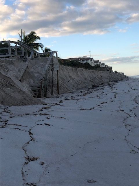
We just saw a really good example of how the Treasure Coast beaches can erode when the wind and surf is coming from a southerly direction.  I saw erosion that ran for miles south along the beach south of the Fort Pierce. inlet.  I also saw photos of a lot of erosion to the north of the inlet and up in the Vero/Sebastian area.  Most of the Treasure Coast showed some erosion from the strong south winds and surf from Ian.

On Wednesday the wind was blowing south to north almost parallel to the beaches, and you could see the waves hitting the beach from a sharp angle.  We talk more about Nor'easters, and with good reason, yet is very apparent that a good south blow can cause some pretty good erosion too.  We've seen that many times before, but this was a very good recent example.  

I believe that there are significant differences between erosion caused by a nor'easter and a south blow.  Despite the deep and lengthy cuts we saw the past few of days, we didn't get the same kind of erosion on South Hutchinson Island (not to mention the tons of sand that accumulated during teh summer and previous years) that we've seen by some nor-easters and the renourishment sand on the Vero/Sebastian area was a factor there, so we didn't get a pure test up there.  I'm convinced the renourishment sand will usually wash away quicker than beaches that build naturally.  I won't get into the reasons for that now, but the beach profile isn't the same.  And that is too bad for the turtles that lay their eggs in the renourishment sand.  Turtle eggs were all over the beaches.

It seems to me that "sou'easters" (the term itself does not seem as natural) have a slightly different effect.  Perhaps it has something to do with the natural south to north path of tropical storms and/or the prevailing contrary longshore drift.  Nonetheless, south winds and swells can certainly cause a lot of beach erosion, and we just saw a good example of that.

I can remember many days of being on the beach when a strong north wind was blowing sand that stung the face or any exposed skin.  It was doing that Wednesday. By Thursday, the beach wind wasn't as strong. Wednesday, you could see the sand blowing along the beach front like drifting snow.  After such a long quiet summer, it was a welcome change.

There were a lot of detectorists on the beach Thursday.  I don't remember if I saw any Wednesday.  I don't think I did.

As I might have mentioned, there seemed to be a lot of younger detectorists Thursday at John Brooks and Frederick Douglass.  I don't know if that is a trend or not.  A good number of them looked like beginners.  Some were very obviously beginners, and a good number of them were using Equinox detectors.  

There were a good number of coins in the ground Thursday despite the number of detectorists covering the areas around the well-known wreck beaches of South Hutchinson Island.  I had no trouble finding coins.  In fact, the modern coins were aggravating me.  Not only were they plentiful, but they were mostly deep.  I almost started passing on penny signals.  

At one beach I was getting into some of the older peanut butter color sand and some older layers of shells that held large pieces of aluminum.  Digging through old compact shell layers with a sand scoop can be difficult and time consuming.  I only hit a few near-surface coins freshly exposed by erosion.

Hard to believe that pulltabs were replaced by the staytabs in the 1980s, so if you were digging pulltabs you might be in layers that are forty or more years old.  And the "new" zinc pennies have been made for forty years now.  How time flies.   I dug some deep and obviously well-seasoned zinc pennies from packed deeper layers.  

With all of the detectorists that have been covering the beaches in recent years, I did't expect to find so so much metal still in the ground, but I'd guess there has been a lot of discrimination going on

---

Source: nhc.noaa.gov.

Source: MagicSeaWeed.com

That one system seems to be following a path similar to Ian, but probably will change.

I haven't yet really looked at or cleaned my own finds.  Just too much going on.

Good hunting,
TreasureGuide@comcast.net


Saturday, October 1, 2022

10/1/22 Report - Beach Photos. Beach Closings. Finds. Predictions.


Written by the TreasureGuide for the exclusive use of the Treasure Beaches Report.

Turtle Trail Friday
Photo by John E.

John E. sent the above photo.  He mentioned that he was into some of the old orange sand and that the beaches were getting back to how they were before renourishment.

As much as I'd like to, I'm not going to be able to get out to detect today, so keep the photos coming - finds as well as beaches.

---

Here is some good information from DJ.

About 6pm last night (9/29 Friday) this picture was posted about beach closures . Since the surf is hitting the dune, people were walking on the dunes up and down the beach at Golden Sands. (Funny how county gov. did not care there was such a huge drop off after they dumped 8 feet of sand on the beach.)Surf is down to 3-4 feet today and 2-3’ Sunday per NWS. To be fair, there were a lot of boards and limbs washing around. People were walking out onto the sandbar in front of Ocean Grill (the city beach accesses there were surprisingly open) Still seems like a lot of sand on the few beaches I saw  yesterday.

McLarty museum is closed for parking lot work and the first paved beach park south of Sebastian Inlet is closed. One of the unmarked dune crossovers between that park and Ambersand was open but the surf was hitting the top of the sloped beach. The slope was renurishment sand and mushy in both directions.

Riomar had lines of seaweed from previous high tides.

Still this is nothing compared to what the west coast is going through.


---

And here is an email and find photos from Mike T.

Good morning Mike T in Stuart here.  It’s been quite a while since we’ve had some decent beach conditions and although Ian brought a lot of destruction to the West Coast we really had some good beach cuts for two days with a few nice finds! A lot of the summer sand was quickly removed in a day or two and it really sets us up for a good fall season.  I found a total of 6 pounds of lead as well on my two hunts Wednesday and Thursday. It’s a good thing I like to fish lol.

     Hope you were able to get out and find a few things and as always thanks for keeping up with the blog we all appreciate it! :)


Thanks Mike.  Nice Finds.

---

About all I did the past couple of days is drive people to doctors.  I have barely looked at my finds so far, but hope to get time to do some cleaning and photos.

The next couple of days, it looks like we'll have something like a 2 -3 foot surf.  After that they are predicting a bigger surf - like 4 - 6 feet.

Don't forget the folks that lost so much.

Good hunting,

TreasureGuide @comcast.net