Written by the Treasuregiide for the exclusive use of the Treasure Beaches Report.
 |
| Found by Schmitts in 2015. |
Not long ago I mentioned the famous 1715-Fleet Anniversary find made by Jonah and the crew of the Capitana in August of 2015. It just before that find that they were finding tons of musket balls. In my experience, lead often comes before gold, so I was thinking they were getting close. But the Anniversary find wasn't the only big find made in 2015. There were plenty, including a great bunch of gold coins, including a fantastic Royal found by the Schmitts. Above is the picture from the gold coins found just about a month earlier than the Anniversary find. And below is the link to that post.
The Treasure Beaches Report Direct From Florida's Treasure Coast.: 7/28/2015 Report - New Photos Of The Amazing Royal Found By Schmitt Family On Treasure Coast Wreck Site. Also Other Coins And Bottom Where Found.
---
In 2003, the Skaftö wreck was found at the bottom of the sea off Lysekil, north of Gothenburg. But it is only now that researchers have been able to carry out analyses of its cargo using new, modern methods.
An international research team, headed by maritime archaeologist Staffan von Arbin at the University of Gothenburg, has succeeded in mapping the origins of its cargo and the probable route of the ship. The study contributes new knowledge about the goods traded in the Middle Ages and the trade routes in that period.
The cargo included copper, oak timber, quicklime, tar, and bricks and roof tiles. Samples of the cargo have been taken up from the wreck during previous underwater archaeological investigations carried out by the Bohusläns museum. But it’s only now that analyses of its cargo have been possible using modern analysis methods....
Here is that link.
Skaftö wreck’s cargo tells a tale of 15th cen | EurekAlert!
---
Metal detectors will be standard in Lake Erie fishing tournaments after cheating scandal...
The investigation started after the local tournament director discovered that the two fishermen considered the team to beat inflated the weight of their catch by stuffing the fish with lead sinkers and then padding the inside of the walleye with fillets, preventing judges from discovering the added weight.,,.
Here is the link for more of that story.
Cheating Lake Erie walleye fishermen: Changes to Lake Erie fishing tournaments after scandal (fox8.com)
Thanks to Rick B. for that link.
---
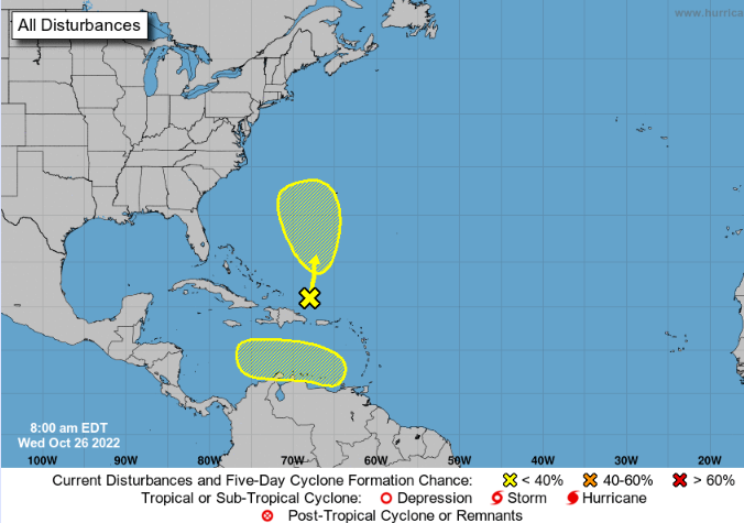
 |
| Source: nhc.noaa.gov |
The red area is going to move west and might develop in a few days.
We will be getting a flow of northeast winds.
As you can see, the surf is supposed to get up around four or five feet.
I plan to discuss this in more detail some time, but one of the sources of error for predicting erosion is the error in predictors, such as surf predictions. The predictions are better, of course, when they are a day or two in advance rather than a week. At this time the MagicSeaWeed predictions are not showing any north wind - just ne and ene.
Good hunting,
Treasureguide@comcast.net
There are a number of factors to be considered for predicting beach erosion. They include the size of the surf, the direction of the swells, direction of the wind, and tides but in addition to the movement of water, it is also necessary to consider the amount of the sand and the lay of the beach and submerged land nearshore.
Theoretically, you could develop a regression equation to predict erosion, but first you would have to define erosion in soe quantifiable way, which would be difficult, for reasons I've explained in the past. Putting that difficulty aside, there are other difficulties.
One big difficulty is the variables you might use to make your predictions are not perfect. For example, if you use the predicted size of the surf, which I would use, the surf predictions are not perfect, and the further out you try to predict, the more error you will find in the surf predictions. They are good a day or so in advance, but not so good a week in advance. I've talked about that before.
One difficulty in predicting erosion, is that erosion can occur at some areas, and at the same time, not at other locations. So that gets to the problem of a qualifiable definition of erosion, which is a solvable problem.
It is fortunate that one variable helps a lot. There is not going to be erosion as long as the surf is small, and that happens a lot. Just checking the surf size will help you save a lot of wasted trips to the beach.
After surf size comes swell direction.
There is going to be little erosion when the water hits the beach straight on, however there may be some at certain locations, even if it is scant and scattered.
.
I consider a four to six feet surf to be sort of borderline. Much of the time (perhaps something like 60% of the time) you will have such a small surf that you will not have significant erosion. With a one or two foot surf, noting else matters much, but when you get a higher surf, then the tides can make a difference, as will the angles. If you woudl create an equation, I'd guess that the largest percent of the variance would be contributed by the surf size factor.
But how do you measure erosion. You'd have to decide how to do that. It is not as simple as it would seem. Of course, you could sijmplify that by coming up with your own rating scale.
---
Ancient Maya stela discovered in Uxmal, Yucatán (mexiconewsdaily.com)