Search This Blog

Wednesday, May 31, 2023

5/31/23 Report - Tropical Disturbance In Gulf. Basics For Beach Detecting Conditions Forecasting and Some Resources.

Written by the TreasureGuide for the exclusive use of the Treasure Beaches Report.

s
Source: nhc.noaa.gov
\
The news today is one of the early tropical disturbances of this hurricane season.  It won't be a big deal, but it is the kind of thing we'll start watching as we hope for a break in summer beach conditions and a shot at beach treasures.

Here is the description and forecast for this disturbance.

An area of disorganized showers and thunderstorms is associated with 
a surface trough of low pressure interacting with an upper-level 
trough over the eastern Gulf of Mexico. Environmental conditions 
appear only marginally favorable for additional development over the 
next several days as the system meanders over the eastern Gulf of 
Mexico. The system is then forecast to move across the Florida 
Peninsula this weekend and emerge into the southwestern Atlantic 
Ocean by early next week. Regardless of development, the system 
could produce heavy rainfall and gusty winds over portions of the 
Florida Peninsula later this week...

I've been checking out windy.com for surf predictions, but it also is good for forecasting tropical weather.

Below is what windy.com forecasts for around late Sunday/early onday when the system has passed over Florida and the winds start to hit Florida from the backside of the system.


One Model Showing Good North Wind for Treasure Coast Around Midnight Sunday

As I said above, I'm not expecting a lot from  this one, but we could get some decent north wind and waves Monday.  While the GFS model is showing next to nothing for Monday, there are models that are showing some nice big waves for Monday.  I'll keep watching this to see how it works out.

---


Here is a really good article that will help you read the surf reports.  Of course the surf reports are made for those interested in surfing, but if you understand the surf reports, that will also help you forecast beach conditions.

Here is the link.

How to read a surf report (surfertoday.com)

Below are some of the basics from that article.


Wave Height

The size of the wave is one of the most important variables of a surf report.

So the significant wave height reveals the average wave height - from trough to crest - of the highest one-third (1/3) of all waves during a 20-minute period...

Groundswells associated with long wave periods, typically 10-to-20 seconds, are known for bringing better and more powerful waves for surfing.

On the opposite side of the spectrum, wind swells with periods of less than 10 seconds will deliver poor-quality surf conditions.

Swell Direction

The direction from which the swell is coming can be expressed in degrees or cardinal points.

As a general rule of thumb, a coastline facing west will get bigger waves if the swell comes from W instead of NNW. That's why the angle of swell is so important.
Wind Speed and Direction

The wind is responsible for creating waves, but it can also destroy a day of surfing even if a groundswell hits the shore.

In most cases, onshore winds will decrease the quality of the waves, while a gentle and steady offshore wind will hold the face of the wave for a little longer before breaking...

I'll probably comment on some of the information in this article from time to time to help translate from surfing to beach metal detecting interests.

----

“No eye has seen, no ear has heard, and no mind has imagined what God has prepared for those who love him.” (Cor. 2:9)

---

Good hunting,

TreasureGuide@comcast.net


Tuesday, May 30, 2023

5/30/23 Report - Beach Conditions Forecasting Resources and Terminology. Crime at the Beach.


Written by the TreasureGuide for the excusive use of the Treasure Beaches Report.

This Morning's Chart Snipped From Windy.com.

As you probably know, I've been searching for a good replacement for the MagicSeaWeed surf charts that I used for so many years.  Above you see a chart from Windy.com.  It provides a lot of good information that can be useful for the beach detectorist, but you might not find it as easy to grasp in a quick glance as the old MagicSeaWeed charts.  The information is there though.  Top to bottom, there is the time of day, wind, wind gusts, waves, swell and swell period.  And it goes out another day or two.  I cut it a little short when I snipped it.  As you can see, this morning the wind is not as strong, from the northeast, and the seas are only around two feet.

I used the old MSW charts so long, I knew not only how the chart translated to what I saw at the beaches, but also what errors the model was likely to make.  

Windy.com not only provides more than the little snippet you see above.  Below is another part of the same display.

Snippet Showing Primary and Secondary Swell at Vero.

So the primary swell is hitting the beach almost directly.  Only a very slight northerly angle.

I didn't like making the change, but being forced to change is sometimes a good thing.  I'm sure the time I spend studying the new charts will eventually result in even better beach metal detecting conditions predictions.

The tide charts are also there.  

Tide Information From Windy.com.

Although the information is there, it is not in such a quick and easy form.  I'm continuing to investigate various resources for the information I most want.  

By the way, as I go from one site to another, I've noticed that there does not seem to be complete agreement.  The information is gathered and presented differently by different sites.  The windy.com site uses and presents three models.  I only presented the display from one of those above.  I think it was the GFS model.  I don't expect the models to vary hugely.   When we start seeing tropical storms, it might be convenient to use a site like windy.com, which also shows the Atlantic wind and wave displays.

---

You might not be totally familiar with all of the terminology.  I'll present some of that from time to time.  What is the difference between waves and swell, for example?

“Swell is best thought of as waves that have enough energy to travel well beyond the place of their origin. It marches in broader lines and with bigger gaps between each crest.”

  • Primary swell is the wave generated due to distant pressure variations usually 1000 miles away. Primary swell travel over very long distances without losing energy due to difference in pressure and primary swell is called ground swell if swell energy can extend down until a 1000 ft deep. This allows better interaction with ocean floor when ground swell moves into shallow water and ground swell will be having longer period suitable for surfing.
  • Secondary swell/swell 2 is wave generated due to another distant pressure variation system usually less significant than primary swell. Tertiary swell is again wave created due to another pressure variation system but usually neglected because of very small wave height.
  • Wind wave is wave generated due to local winds. They will be usually having less than 10s of wave period, travel very short distance. Wind waves can be treacherous/choppy for smaller boats due to shorter wave period.
We use a lot of terms that can be easily confused, such as waves, swell, seas, and surf.  And there is a difference between the marine forecasts and surfing forecasts.  The surfing forecasts seem to be more about nearshore conditions, which is why they are more relevant and helpful for the detectorist than some marine forecasts.

From time to time I'll add some additional terminology and explanation and try to make it more clear and easy to understand.

---

Remember when you had to worry about sunburn or jellyfish when you went to the beach.  Both of those got me at one time or another, but those are minor concerns compared to what you have to be concerned about these days.  Yesterday (Memorial Day) there was a shooting at the very popular Broadwalk of Hollywood Beach, and at least nine people were shot, according to the news on twitter.  CNN and many of the other news outlets haven't said a word about it, perhaps because it wasn't a white supremacist that did the shooting.  I thought they would be rushing to blame it on the lack of gun control in Florida, but they have to be careful about how they present this story, if they do at all.  I suspect they'll try to make it about gun control and DeSantis, despite the fact there were shootings at beaches in blue states as well.

I spent a lot of  time metal detecting at  Hollywood Beach back a few decades ago.  It was then a place where many Canadians would spend the winter and many local youth would gather.  I've told some of my metal detecting memories from there in previous posts.  You could usually find some jewelry at Hollywood Beach even if it wasn't the valuable kind that you'd find at Miami.  The gold was mostly 10K.  There were some class rings as well.

In the video of the shooting, I could see the bandshell, which is very near where I found my first ever metal detected silver ring.  

If there is a crime problem at your favorite beach, one thing you might do is go early in the morning and detect with a partner.  I often preferred sunrise hunts anyhow.  There are fewer people at the beaches, the water is more calm and it isn't quite as hot.  

The weekend shootings were not only in Florida.  There were two shootings at Revere Beach over the holidays, for example.  Revere Beach is in Massachusetts.


Good hunting,
Treasureguide@comcast.net

Monday, May 29, 2023

5/29/23 Report - Remembering on Memorial Day. Beach Conditions and Some New Finds.


Written by the TreasureGuide for the exclusive use of the Treasure Beaches Report.


---


An Eroded Beach In Martin County This Weekend.


I received these photos and the following message recently from Mike T.

 Haven’t had much to share lately as conditions have been challenging for a while as you know. The big swell on Friday night from the Northeast definitely opened up a few spots here in Martin County. It was not everywhere, but I have been watching a few spots closely and the angle and size of the ways combined with the tide opened some big horseshoe areas that led to some good hunting Saturday morning.

Not every area produced the same but one spot in particular I found had not been cut back this far in a long time. Sometimes you just have to get out there and take a look and try a few spots and see what happens.

The gold ring ended up being plated, but the silver ring was a nice little piece definitely had been down there a while. It was very dark gray and crusty, but cleaned up real nice. Quite a few crusty green coins from the 70s and of course the ever present nails as I was hunting with my PI machine. It felt good to get out there and dig a bunch of holes and it was a beautiful day.
 
I hope everyone has a safe Memorial Day weekend and remember the reason we can enjoy our freedom and go on treasure hunts and enjoy the outdoors freely is because of those who gave the ultimate sacrifice.

Eroded Beach in Martin County.

I showed photos of John Brooks after the Friday swell that Mike mentioned.  It didn't affect John Brooks as much.  There are times when some spots will open up even while others are not affected.  I've discussed the reasons for that before.  

You might remember several months ago, I think it was November, when things opened up in Martin County and an indigenous skull was uncovered by erosion.  

Here are some of the finds Mike made.

Recent Finds by Mike T.


Here are the two rings Mike found.


Two Rings Found by Mike T.

Thanks for sharing Mike.

There are times when erosion is widespread and times when it is found at fewer places, but as I've said a million times, there is always some place to hunt and something to find.

To some extent, there is a correlation between the amount of erosion and the age of finds.  

Erosion can be cumulative.  It can be additive over multiple events.  

Waves can be affected by a local rainstorm and the winds generated by something like that too.

Overall conditions are not great for finding old shipwreck coins on the beach right now, but you can still go out, have some fun and find some nice things.

Here is a surfline chart fairly well represents much of the Treasure Coast even though it is for Walton Rocks.  You can select various areas.   

The surf is now around two or three feet and will be decreasing today and tomorrow.


There was a nice north wind this morning that will help out any areas that are already lowered and in a good location.

In the future I'll discuss using some of the charts you can find online.  

It might take a little getting used to.


Good hunting,
TreasureGuide@comcast.net


Saturday, May 27, 2023

5/28/23 Report - Treasure Coast Beach Conditions Heading Into the Memorial Day Weekend. Photos and Forecast.


Written by the TreasureGuide for the exclusive use of the Treasure Beaches Report.

John Brooks Beach Saturday Morning.


I went to the beach Saturday morning just to check the beach conditions and relate what I saw beach to the buoy data that I found online.  

At John Brooks you could see that the waves were hitting at a bit of an angle and you could see the little cut right where it was hitting at a very favorable angle. (above).

The beach front were very mushy.

The meteorologist on the radio was talking about big swells and waves, but that is not what I saw at John Brooks beach, and I think it would have been the same many places. 

As you can see from the photos, the waves were more like two feet - if that.


John Brooks Beach Saturday Morning.


The only other beach I saw was Fort Pierce South Jetty and south of that.

Fort Pierce South Jetty Beach Saturday Morning.

The slope was very mushy there too.

The fellow in the middle of the photo below was metal detecting.


Fort Pierce South Jetty Beach Saturday Morning.

DJ visited Turtle Trail and sent the following beach photos.


Turtle Trail Saturday.


There is sea weed on most beaches.  There was an article in one of the newspapers about that.

In the distance (photo above) you can see the tops of some of the blue bags.

That beach looked better than John Brooks, which I don't expect to recover for years.  All that sand to the north will be moving south.

Turtle Trail Saturday.


Turtle Tail Saturday.

Thanks DJ.

---

As you know, the MagicSeaWeed site has made some changes and I'm looking for a good replacement.  I am looking for good sources of data that apply well to beach conditions.  What is important to boaters is different to some extent from what is important to surfers, and that is a big part of what detectorists need to know.

Here is a decent site that gives marine forecasts that provide most of what you will need.  You just have to look outside to get a good idea of the current wind strength and direction.  Of course, you will also want to check a tide chart.

Here is the marine forecast for the Fort Pierce area as displayed Saturday night.


The following link will get you there.  You can also select areas other than Fort Pierce.

7-Day Marine Forecast 27.45N 80.32W | Sebastian Inlet to Jupiter Inlet 0-20 nm (weather.gov)

I'll be refining this over time and making it easier.  Also I be providing some definitions and explanations of the data.

Good hunting,

Treasureguide@comcast.net


5/27/23 Report - Florida Fossil Graveyard. Fort Pierce Shark Attack. Use of Ultraviolet Light. Marine Forecast Data.


Written by the TreasureGuide for the exclusive use of the Treasure Beaches Report.

Source: MSN.com link below.


North Florida museum of Natural History made a “once-in-a-lifetime” discovery when they found an elephant graveyard of an extinct relative of elephants called gomphotheres...

According to Rachel Narducci, collection manager of vertebrate paleontology at the Florida Museum, it’s likely the fossils were successively deposited or transported to the area. “Modern elephants travel in herds and can be very protective of their young, but I don’t think this was a situation in which they all died at once,” she said. “It seems like members of one or multiple herds got stuck in this one spot at different times.”

Over the last seven years, paleontologists working at Montbrook have discovered the oldest deer in North America, the oldest known skull of a smilodontine sabertoothed cat and a new species of extinct heron. Fossil mainstays from the time, like bone crushing dogs and short-faced bears, also show up scattered across the wide-brimmed fossil bed. Despite the diversity of fossils at Montbrook, most of these animals were interred after being transported by running water, and their remains are rarely found intact. The discovery of several complete gomphotheres was entirely unexpected.

Here is the link for more about that.

'Once-in-a-lifetime': 5 million-year-old 'elephant graveyard' found in Florida (msn.com)

I've posted numerous Treasure Coast beach fossil finds in the past including those of mammoths,  sloths, tapirs, etc.  Here is an example of one post featuring a variety of such fossils.

The Treasure Beaches Report Direct From Florida's Treasure Coast.: 6/12/20 Report - Miscellaneous Sampling of Treasure Coast Fossils: Some Being Millions of Years Old. Evolution of Horses of North America. Labeling Finds.

---

A thirteen-year-old Fort Pierce girl was bitten on her arms, legs and stomach by a shark while recently swimming off Fort Pierce.

Here is that link.

Florida girl, 13, fought back against a shark after being bitten on her arms, legs and stomach (nbcnews.com)

===

Source: See FoxNews link below.


Ultraviolet light reveals to scientists a hidden Bible passage 1,500 years later.

Kessel shared that he used ultraviolet photography to see the earlier text under three layers of words written on a palimpsest, an ancient manuscript previously written on that people have scraped off and reused multiple times...

Here is that link.

Ultraviolet light reveals to scientists a hidden Bible passage 1,500 years later | Fox New

I've talked a lot in the past about the use of ultraviolet light to help find or identify things such as gem stones, fossil sea shells, depression glass, vasoline glass and more.

Here is one example.

The Treasure Beaches Report Direct From Florida's Treasure Coast.: 7/11/17 Report - Photographs For Viewing Coins and Artifacts. Looking For Lost Items: A Reminder.

---

So they found what they kept calling a coin on Oak Island.  I couldn't see why they thought it was a coin.  I saw nothing to make me believe it was a coin, although I was only seeing it on the TV screen.   I mentioned my doubts in my 2/23/23 post (Treasure Beaches Report: Pt. 2. (2020 and Beyond). : 2/23/23 Report - 15th Century Gold Coin Found. Civil War Explosive Dug Up. Exercising Powers of Discernment. (tbr2020.blogspot.com)   So the last I saw, they were in Italy and some "expert," I guess it was, suggested it was a coin weight.  I doubt that too.  I just caught a little of that and think that is what he was saying.  Sometimes I have a hard time telling when they simply don't know or when they are trying to add to the drama of the show by misinterpreting finds.  

---

I'm having a hard time finding a good replacement for the old MagicSeaWeed charts.  I'd think it would be easier, but everything I see is either too complicated or doesn't provide the information I want.  I'm sure I'll come up with something good before long, but still looking.  

I do plan on doing some posts to help explain some of the more complicated charts such as the following from the National Weather Service.


Good information there, but it isn't easy to get at a glance unless you have studied it.  Bigger waves are shown on 5/27.  

Significant Wave Height, as shown by the top chart, is defined traditionally as the mean wave height of the highest third of the waves. That is at the buoy. This will take some study.  These charts don't seem to translate to beach conditions as directly and easily as the MSW charts that I used for so long. Maybe it will just take some time to get used to these new charts and correlate them to actual observed beach conditions.

This buoy is off Pepper Park (41114).

Good hunting,

TreasureGuide@comcast.net


Friday, May 26, 2023

5/26/23 Story of the First Settlement by Columbus. One Trillion Dollar Platinum Coin. Science. Beach Cam.


Written by the TreasureGuide for the exclusive use of the Treasure Beaches Report.

Getty Image
Source: See BBC.com link below.

The mystery of La Navidad.

It was Christmas Eve 1492. Christopher Columbus and his three ships had already arrived in the Caribbean, and had toured some of its islands. On board the Santa Maria, off the north coast of Hispaniola, the admiral soon went to rest, since at dawn the next day he was scheduled to meet with a local cacique, Guacanagarí.

Possibly the four bell doubles that announced midnight rang, accompanied by the traditional "Good is the one that goes, better is the one that comes!" The sea was calm.

No one heard the signs of the boat approaching a sandbar until it was too late...

Here is the link for a much longer and interesting read.

The mystery of Christmas, the first European settlement in America built with the remains of one of Columbus' ships - BBC News World

---

There is some talk about "The $1 trillion platinum coin with which the U.S. government could avoid bankruptcy."...

This has caused some experts and analysts to return to talk about an option – far-fetched for many – of last resort: the issuance of a US $ 1 trillion platinum coin to save the country from bankruptcy...

"They would just have to write $1 trillion in the currency and send it to the Federal Reserve," Philip Diehl, former head of the U.S. Mint, told NPR's Marketplace program.

Although many laugh imagining that it would be a gigantic and heavy platinum coin, the truth is that it could be as small as a simple ordinary quarter-dollar coin that is kept in your pocket...

Here is the link for more about that.

The US$1 trillion platinum coin with which the US government could avoid bankruptcy - BBC News World

That is a solution proposed by a blogger but discussed by high level government officials as a possibility.  That is what the country has come to.  And it isn't unintentional.

---

NASA astronaut on science and Christianity.

NASA astronaut says science 'doesn't contradict' Christianity | U.S. News (christianpost.com)

---

Until I find some good combination of sources or something to adequately replace the MagicSeaWeed charts, here is a good site that shows the Jensen beach cam, wind data and tide chart.

Jensen Beach Webcam (video-monitoring.com)

===

I'm going to do some posts on how to interpret wave data as it affects beach conditions.  I'll only say now that there is a difference between swells and waves and the wave height at the buoys is more relevant for mariners than surfers.  A six-foot wave height at a buoy will not be that big near the beach, which is what surfers and detectorists will be more concerned about.  I'll get into some of the subtleties in future posts.

Good hunting,

Treasureguide@comcast.net


Thursday, May 25, 2023

5/25/23 Report - Tired Old Environmentalist Failure. First Evidence of Colonial Wine. Wind Waves Data Sources.


Wrtten by the TreasureGuide for the exclusive use of the Treasure Beaches Report.


The Osborne Reef is an artificial reef project situated off the coast of Fort Lauderdale, Florida. It was one of many attempts in the 1970s and 80s to mimic the environmental benefits of coral reefs using old tires, but it has become an environmental disaster. ..

In the 1970s, a local nonprofit created the Osborne Reef by dropping more than two million tires into Florida’s coastal waters in an attempt to create an environment where marine life would thrive... 

Goodyear, which provided many of the tires, even christened the reef by dropping a gold-plated tire into the ocean from the Goodyear Blimp...

Wonder where the gold-plated tire is.

“Ultimately, the well-intentioned project failed,” 4ocean wrote in an Instagram post sharing eerie photos of the reef. “And now 4ocean is stepping in to clean them up!”...

Here is the link for to read the rest of the article.

Group shares eerie photos of disastrous man-made reef off coast of Florida: ‘500,000 tires left sitting at the bottom of the ocean’ (msn.com)

A rolling stone gathers no moss, or so they say, and I guess tires, rolling or not, will make no reef.  

---


Scientists have found what they believe to be the earliest known evidence of wine drinking in the Americas, inside ceramic artefacts recovered from a small Caribbean Island. Forty ceramic sherds were examined in the first study to have used molecular analysis techniques – Gas Chromatography and Mass Spectrometry - to investigate 15th century pottery from the Puerto Rico region...

The analysis included sherds from a Spanish olive jar that could be dated between 1490-1520 AD. The rounded style of the jar shows it to be this early and aligns it to the timing of when Columbus first noted the existence of the island in his diary in 1494...

Here is the source link.

Earliest evidence of wine consumption in the Americas found in Caribbean (cranfield.ac.uk)

---

Still searching to find a source of detailed information in a form that makes it easy to make predictions about beach detecting conditions since they changed the MagicSeaWeed site.

Yesterday I pointed out the NCBC site.  You can find a lot of information on the NDBC site, including detailed data from buoys along the coast.  It doesn't make it as easy as the old MagicSeaWeed chart did, but there is a lot of information there.  

See NDBC - Station 41114 Recent Data (noaa.gov) for example.  That gives you the wind and wave data from the bout near Pepper Park.

And Sebastian Inlet Webcam (sebastianinletcam.com) provides wind data and pictures of the Sebastian area beach.   Below is an example.

North of Sebastian Inlet Beach Cam Showing State of Beach This Morning.

If you are ever thinking of running out to Sebastian, you might want to check this site first.

---

Most wokesters never have to wake up to go to work or take the kids to school so they can sit around and wait for a community organizer to call them out to a protest.  Without any meaningful sense of significance they become the eager tool of the grievance industry.

---


Here is the NDBC prediction for today.


The sea measure given by NDBC does not translate exactly like the MagicSeaWeed data.  

Still seeking for something similar to the MagicSeaWeed charts that I always used in the past.

Thanks to DJ for his help.

Good hunting,

TreasureGuide@comcast.net

Wednesday, May 24, 2023

5/24/23 Report = 16rh Century Shipwrecks Carrying Chinese Porcelain and Wood Discovered. Forecasts.

Written by the TreasureGuide for the exclusive use of the Treasure Beaches Report.

Porcelain From Newly Discovered Chinese Shipwreck
Source: See MiamiHerald link below.


The shipwrecks were discovered about 1 mile below sea level on the northwest slope of the South China Sea, according to a May 22 news release from the State Administration of Cultural Heritage via the Institute of Archaeology at the Chinese Academy of Social Sciences. Here’s what archaeologists have found in the shipwrecks so far. A TROVE OF PORCELAIN Experts determined that the first shipwreck dates to the Zhengde period of the Ming dynasty — which lasted from 1506 until 1521...

Experts determined that the first shipwreck dates to the Zhengde period of the Ming dynasty — which lasted from 1506 until 1521. 

The wreck was overflowing with porcelain goods, including bowls, cups, plates and jars in various glaze colors, officials said.

Here is that link.

Shipwrecks full of porcelain, wood found in South China Sea | Miami Herald


BEIJING, China – Researchers are celebrating a milestone in China's development of deep-sea archeology after two large ancient shipwrecks were recently discovered in the South China Sea.

China's State Administration of Cultural Affairs said this was the first time ancient ships sailing and returning to the same sea area had been discovered in the country.

Yan Yalin, the agency's director of archeology, said that this major discovery proved the historical fact that Chinese ancestors developed, utilized and traveled to and from the South China Sea.

Here is another link on one of the two wrecks.

Ancient shipwreck filled with porcelain treasure discovered in South China Sea (yahoo.com)  

Thanks to DJ. for that link.

There are many ways that archaeology and politics are intertwined, but above is a clear example of  China using an archaeological find to support their claims to the South China Sea.

 In Beijing’s eyes, these vast waters and their bits of natural and artificial land are already in China’s possession and under its administration—a conviction embodied in the ban on foreigners who fish in them without China’s prior permission.

You might be aware of international conflicts in that area.

---

Due to changes made by MagicSeaWeed.com, I was looking for another source surf predictions and other information relevant to beach conditions.  I found one site that is pretty good.  It is the National Weather Service Marine Forecast.  I'll see how good that works.  Nearshore surfing waves are more relevant than the surf farther out to sea.  Here is sample of what you can find on the NDBC site.


It will take me some time to learn to interpret this data as well as the magicseaweed charts that I have been using for so long.  Nonetheless there is some good data provided here. I'll still be looking for other charts that are more similar to those that I've used for so long.

Here is the link.

NDBC - National Weather Service Marine Forecast FZUS52 KMLB (noaa.gov)

Mitch King has been using the following web site while looking for a replaceent for MSW, which now takes you to Surfline.com...

Vero Beach (ocean)'s Tide Charts, Tides for Fishing, High Tide and Low Tide tables - Indian River County - Florida - United States - 2023 - Tideschart.com


There is nothing significant on the National Hurricane Center charts now.

Good hunnting,

TreasureGuide@comcast.net

Tuesday, May 23, 2023

5/23/23 Report - New Titanic Images. Andean Cross or Chakana. Spanish Colonial Period mining and metallurgy


Written by the TreasureGuide for the exclusive use of the Treasure  Beaches Report.

New Titanic Images
Source: See LiveScience link below.


A new scan of the Titanic shipwreck made with more than 715,000 images has revealed the world's most famous shipwreck as we've never seen it before...


"This model will allow people to zoom out and to look at the entire thing for the first time. So, by capturing this 3D model, what we're able to do is visualize the wreck in a completely new way, there's all kinds of amazing small little details that you can see," Gerhard Seiffert, a 3D imaging specialist at the deep-sea mapping company Magellan that conducted the scan alongside the filmmakers Atlantic Productions, said in a statement...

Here is the link.

I found a free ebook on mining and metallurgy published in 1550.  It provides a lot of information on the mining and use of metals in the 16th century.  Here is are a few excerpts.  

As to Agricola's contribution to the sciences of mining and metallurgy, De Re Metallica speaks for itself. While he describes, for the first time, scores of methods and processes, no one would contend that they were discoveries or inventions of his own. They represent the accumulation of generations of experience and knowledge; but by him they were, for the first time, to receive detailed and intelligent exposition. Until Schlüter's work nearly two centuries later, it was not excelled. There is no measure by which we may gauge the value of such a work to the men who followed in this profession during centuries, nor the benefits enjoyed by humanity through them...

Below you have a breakdown of the books or chapters.

 I have written these twelve books De Re Metallica. Of these, the first book contains the arguments which may be used against this art, and against metals and the mines, and what can be said in their favour. The second book describes the miner, and branches into [Pg xxx]a discourse on the finding of veins. The third book deals with veins and stringers, and seams in the rocks. The fourth explains the method of delimiting veins, and also describes the functions of the mining officials. The fifth book describes the digging of ore and the surveyor's art. The sixth book describes the miners' tools and machines. The seventh book is on the assaying of ore. The eight book lays down the rules for the work of roasting, crushing, and washing the ore. The ninth book explains the methods of smelting ores. The tenth book  instructs those who are studious of the metallic arts in the work of separating silver from gold, and lead from gold and silver. The eleventh book shows the way of separating silver from copper. The twelfth book gives us rules for manufacturing salt, soda, alum, vitriol, sulphur, bitumen, and glass.

And here is a bit on the discovery of ores.

But by skill we can also investigate hidden and concealed veins, by observing in the first place the bubbling waters of springs, which cannot be very far distant from the veins because the source of the water is from them; secondly, by examining the fragments of the veins which the torrents break off from the earth, for after a long time some of these fragments are again buried in the ground. Fragments of this kind lying about on the ground, if they are rubbed smooth, are a long distance from the veins, because the torrent, which broke them from the vein, polished them while it rolled them a long distance; but if they are fixed in the ground, or if they are rough, they are nearer to the veins. The soil also should be considered, for this is often the cause of veins being buried more or less deeply under the earth; in this case the fragments protrude more or less widely apart, and miners are wont to call the veins discovered in this manner "fragmenta."

Further, we search for the veins by observing the hoar-frosts, which whiten all herbage except that growing over the veins, because the veins emit a warm and dry exhalation which hinders the freezing of the moisture, for which reason such plants appear rather wet than whitened by the frost. This may be observed in all cold places before the grass has grown to its full size, as in the months of April and May; or when the late crop of [Pg 38]hay, which is called the cordum, is cut with scythes in the month of September. Therefore in places where the grass has a dampness that is not congealed into frost, there is a vein beneath; also if the exhalation be excessively hot, the soil will produce only small and pale-coloured plants. Lastly, there are trees whose foliage in spring-time has a bluish or leaden tint, the upper branches more especially being tinged with black or with any other unnatural colour, the trunks cleft in two, and the branches black or discoloured. These phenomena are caused by the intensely hot and dry exhalations which do not spare even the roots, but scorching them, render the trees sickly; wherefore the wind will more frequently uproot trees of this kind than any others. Verily the veins do emit this exhalation. Therefore, in a place where there is a multitude of trees, if a long row of them at an unusual time lose their verdure and become black or discoloured, and frequently fall by the violence of the wind, beneath this spot there is a vein. Likewise along a course where a vein extends, there grows a certain herb or fungus which is absent from the adjacent space, or sometimes even from the neighbourhood of the veins. By these signs of Nature a vein can be discovered.

There are many great contentions between miners concerning the forked twig...


If you want to look through the entire book, here is the link.

The Project Gutenberg eBook of De Re Metallica, by Georgius Agricola.

There are numerous woodcut illustrations.

---

 Lima, May 15 (EFE).- A group of archaeologists has discovered a nearly 4,000-year-old temple complex on Peru’s central coast that may contain South America’s most ancient “Chakana” (Andean cross) carved into one of its friezes....

Here is the link.,,

Andean cross found at Peru temple ruins may be oldest ever - La Prensa Latina Media

The Chakana or Incan Cross is a very common symbol that can be displayed in a large number of ornate forms.  


Here is another link on the proposed meanings.

Meaning of Chakana – the Incan cross (explorebyyourself.com)

---


China’s overarching aim is “to rearrange the world order” said Lisbon attendee Elizabeth Economy, who’s participating in her second Bilderberg as Biden’s senior adviser for China at the Department of Commerce.

The rise of what she called “a China-centric order with its own norms and values” is a gauntlet thrown down at Bilderberg, the elite forum which has helped frame and foster the western world order for nearly seven decades. They don’t mind a new world order, but they want it to be manufactured at Bilderberg, not made in China...

At Bilderberg’s bigwig bash two things are guaranteed: Kissinger and secrecy | Bilderberg | The Guardian

I told you years ago that the great reset guys will weaken Western Civilization to the delight and benefit of China, which will eventually walk in and take over.  They have been infiltrating every Western power center for years and are very well positioned.

Here is another thing I warned about.

FBI misused surveillance tool on Jan. 6 suspects, BLM arrestees and others (msn.com)

---

Anwer to yesterday's question.

Four reale - 18th century.

Two reale - 16th century.

Half reale - 17th century.


---

Good hunting,

TreasureGuide@comcast.net.


Monday, May 22, 2023

5/22/23 Report - Cleaning Coins and Three Silver Treasure Coast Reales From Different Centuries. Tropical Storm Time.


Written by the TreasureGuide for the exclusive use of the Treasure Beaches Report.


Close View of Four-Reale Surface..

Take a close look at the coin shown above.  Can you tell if it has been cleaned or not?  

You hear a lot about cleaning coins.  You'll often read or hear that you should never clean a coin, but when if you are talking about centuries old shipwreck coins, they are often cleaned - and heavily.  I think they are often over cleaned, but some collectors seem to like shiny silver coins rather than the naturally blackened coins as they are often found.  And silver treasure coins found on the beach are often so corroded or encrusted that you can't even tell what they are without some cleaning.

Here is a link to a good article about cleaning coins.  I'll post a couple excerpts fron that article below.

Cleaned Coins: How To Tell If A Coin Has Been Cleaned & Why It Matters | U.S. Coins Guide (thefuntimesguide.com)

Coins have been cleaned if they have been 

  • Washed with soap, toothpaste, or baking soda
  • Dipped in jewelry cleaner
  • Soaked in ketchup, taco sauce, vinegar, lemon juice, or another acidic condiment
  • Rinsed in bleach, motor oil, or grease
  • Scrubbed with a pad, steel wool, or another type of abrasive cleaning implement
  • Polished with any type of cleaner or rag
  • Doctored in any way to alter the appearance of the finish.

It is common practice to use electrolysis or acid on silver treasure coins.  That can be done well or poorly.  I personally like minimal cleaning.  You can always do more later, but you can't go back once you over-clean.

The four-reale shown above has been cleaned, and there are some obvious signs.  Notice the difference between the shiny high spots and the darker and rougher depressed areas.  

According to the site, cleaning coins is acceptable when

  • The coin has ugly and potentially damaging green polyvinylchloride (PVC) goo from an old plastic coin holder.
  • The coin has loose dirt and debris on it.
  • An ancient coin needs cleaning for proper attribution or identification.

You might want to read the entire article.  


 Two Reale.

Compare the surface of the coin immediately above with the one at the top of the post.  The surface is uniform.  There are no shiny high spots contrasting with duller and rougher low spots. The grains of sand on the surface makes that one too easy.  It has not been cleaned.


Half-Reale


This one has been cleaned, but it isn't as easy to see the difference in the surfaces, but an expert could easily tell it has been cleaned.  

It was totally obscured by encrustation when found, but the surface underneath the crust was still in remarkable condition.

The three coins shown above are from three different beaches and three different centuries (16th, 17th, and 18th).  Can you tell which century each coin is from. Lets call them 1, 2 and 3 from top to bottom.  

Let me know if you can identify these from the images alone.

Which one do you think is most likely from the 1715 Fleet.

---

It is the time of year when the surf remains small unless we get a storm or something.  We are well into summer beach conditions.

There is one disturbance in the Atlantic.

Source: nhc.noaa.gov

Good hunting,
Treasureguide@comcast.net


Sunday, May 21, 2023

5/21/23 Report - Maybe It Is Time To Try Something Different. A Few Thoughts and a Couple Finds.


Written by the TreasureGuide for the exclusive use of the Treasure Beaches Report.

On the Treasure Coast you can find old shipwreck treasures, modern coins and jewelry, fossils, bottles and more.  There is a lot to find, but for some things, such as gold nuggets or natural gems, you'll have to travel to other locations.

Different people like to hunt different kinds of treasure.  Some are driven to find the most valuable things they can, while others are more interested in history or get on the trail of a particular story or puzzle.  Once a person gets on the quest for a particular type of treasure, 

One factor that will likely influence what you hunt, is what is available in your area.  Of course you have to find out that they are in your area, but it is a big help if you have managed to find one or a few because you then know not only that they are there, but you also know a specific location where they can be found and you become confident that you know how to find them.

If you just go out and hunt an area without targeting anything in particular and just hunt hoping to find something valuable or interesting, you might luckily have success, but the probability is fairly low.

Still, I've posted plenty of stories over the years of stories showing that many great finds are made by accident and beginners - even first-time detectorists - can make great finds.  If you are out there hunting, you've taken the first step, and dramatically improved your chances.  Being out there is an important step and a big part of the battle.

Here is my formula for metal detecting success.   Success = L + T + Sk + E + D+ N + A.

I won't go into all the factors now.  You can use the link below if you want a more complete discussion, but the letters stand for Location, Time on task, Skill, Effort, the Detector you use, Networking, and Access to areas.  

Treasure Beaches Report: Pt. 2. (2020 and Beyond). : 5/4/20 Report - New Revised Formula For Metal Detecting Success. Gruesome Bit of Treasure Coast History. (tbr2020.blogspot.com)

Each factor requires some additional explanation or clarification.  For example, location and time is an interaction and the formula should therefore have a multiplication sign instead of a plus sign, but the individual factors are the important thing.  The formula could use soe fine tuning though..


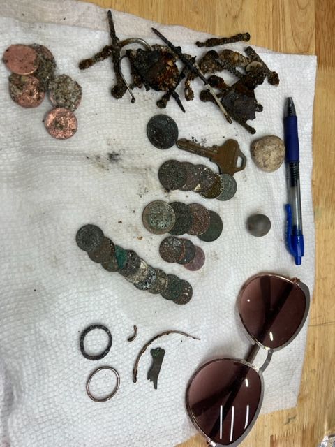
A Couple 2023 Finds.

Don't fall into the trap of doing the same thing over and over again if you are hoping for different results.  It might not be insanity, but it can be unproductive, and there are times when you will have to make some changes.  What worked in the past will not always work in the future.  Conditions will change.  And to be optimally productive, you will have to make some changes too.

Having success in the past, can lock you in.  It is natural after having success to try the same thing again, and that might work a few times, but eventually it will probably show diminishing returns..  

If you look at the factors in the formula and check each of them, it might help you think of  some things you might try changing.  You might need a change in location, you might need to spend more time or maybe even change the time of day you hunt.  That can be important, as simple as it sounds.  

Of course we can always try to increase our skill level, make a greater effort, trying some things that might be more difficult, or select a better metal detector for the situation.

Sometimes the change that is required is a very small change.  When beach hunting, you might follow a  certain line.  A small change in path can make a big difference.  I've talked about search strategies in the past, but it is very easy to get in the habit of taking the same path.  You can do that without thinking about it.

As the result of various factors, I've done very little shipwreck beach hunting this year.  I've done some modern jewelry hunting too, but mostly bottle hunting.  If you judge by the economic value of finds, jewelry hunting has been by far the most productive for me by far this year, as it was in years past when I was doing a lot more metal detecting.  Bottle hunting has been easily available to me, and I've been doing a lot more of that.  I can do it when I don't have time to do much else. 

The thing I don't like about jewelry hunting is when you find something, you know that there is somebody that lost it.  I have mixed feelings about finding some pieces of jewelry.  I'm sorry somebody lost the item, but it is good to find it and possibly be able to return it.  You have to do your research to find the owner.  That kind of research is not my favorite kind of research.  I'd rather be researching an old artifact.  

---

You might find this site handy.

COLONIAL SPANISH TERMS (somosprimos.com)

---

I just saw a television program last night that I thought was really good - This is Mark Rober, which was on the Discovery channel.  

The title doesn't tell you very much, and so I never checked it out before, but liked it a lot.  It is about problem solving and engineering fun projects.  Here is a link.

Watch This is Mark Rober: Stream Series Premiere live, TV - How to Watch and Stream Major League & College Sports - Sports Illustrated.

---

Watch out.  It appears that pregnant ladies are running around attacking and stealing from healthy young men in New York.  At least that was one big story yesterday.

---

The magicSeaWeed web site has changed.  You have to sign-up to get the charts I have been using.  I'll try to find something else as good or better.

The Treasure Coast surf will be around three feet today.

Good hunting,

TreasureGuide@comcast.net