Search This Blog

Thursday, August 31, 2023

8/31/23 Report - Idalia Does Its Damage and Moves Away But Could Send Us Some North Winds This Weekend.

Written by the TreasureGuide for the exclusive use of the Treasure Beaches Report.

John Brooks Wednesday Around Noon.

Drew was out yesterday and sent the above photo and following email message.

Looking south from John Brooks approx noon. Definitely less sand than yesterday but still sandy. Firm by the water at around noon.

2 targets today at waters edge 6-8 inches. Fish hook and a modern coin.
~Drew

Thank for the report Drew.

---


Source: nhc.noaa.gov

Idalia is now south of the Outer Banks of North Carolina.  The Outer Banks hunters will probably get some good hunting.  

We now have another tropical storm - Jose.  It doesn't look like it will affect us much.

Although Idalia has left Florida and done its damage to the West Coast and Panhandle areas of Florida,
it will still have an additional impact on the Treasure Coast.

Idalia Cone As Shown by nhc.noaa.gov.

We are getting southwest winds now, but when Idalia moves away from the coast a little, it will send us some northish winds for a day or so.


Idalia After It Has Moved Away From Land.
Source: Windy.com.

As you can see from the ECWMF model output provided by Windy.com and shown above, it is expected to send the East Coast of Florida some northish winds.  That will produce some bigger surf for the East Coast.

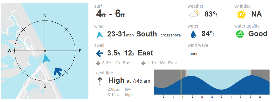
Below you see the SurfGuru surf chart.


Surf Chart from SurfGuru.com.

As you can see, today the Treasure Coast surf is only around two or three feet, as we get southwest winds, but Saturday and Sunday as Idalia moves out, we'll get the north/northeast winds and a bigger surf.  

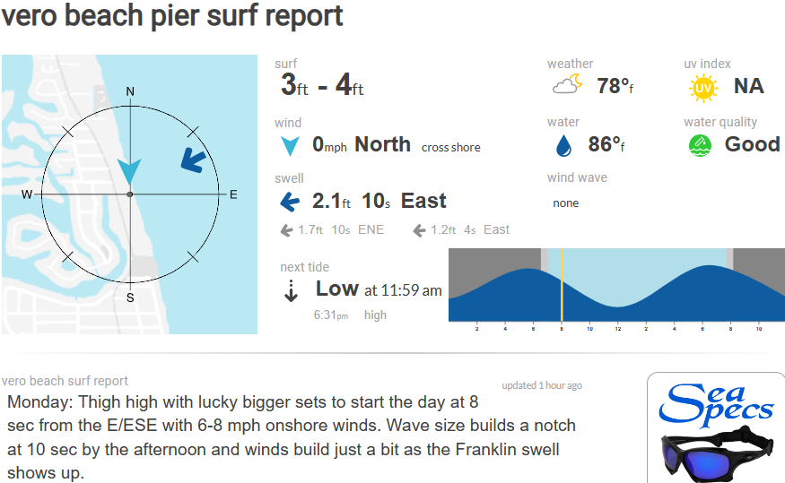
That chart is for the Vero Pier area.  Of course, you can select SurfGuru.com surf charts for various other areas of the Treasure Coast, and you'll see some slight variation from area to area.

Below is today's prediction from SurfGuru..


Perhaps the most interesting and impactful thing for today is the size of the tides.  The high tide will be over four feet, and we'll have a negative low tide.  

There is still a lot going on to watch in the tropics.  Before long, we could get something to wipe a big part of the renourishment sand off of our beaches.  Don't forget that the renourishment sand is also piled in front of the beaches. 

Idalis has been a round about storm for the Treasure Coast.  I don't want hurricanes to hit anybody, but I'd like to see something dramatically improve our beach metal detecting conditions.  For us, and I might say thankfully, Idalia has been a roundabout storm that might yet have some impact on us, but so far it hasn't been much.  Too bad such nice high tides were partly counteracted by west winds.  Still, if you can find the right spots, those tides might produce some nice finds.  Once again, it helps to know where the vulnerable areas are.  Check around where there are obstructions, natural or man-made.

---

I have a lot of other stuff to talk about once the tropical weather settles down.  Until then I'll be keeping on top of that.  You don't want to miss a great and all-to-rare opportunity when mother nature presents one.

Good hunting,
Treasureguide@comcast.net

Wednesday, August 30, 2023

8/30/23 Report - Idalia Hits Big Bend Expected To Reemerge in Atlantic Sending Winds and Surf Our Way Again.


Written by the TreasureGuide for the exclusive use of the Treasure Beaches Report

Source: nhc.noaa.gov.

You can see the cone for Idalia.  It is probably a good thing that it stayed out from Tampa and hit a little farther north, although it looks like it was pretty nasty up there.  The thing I haven't been talking about is what it is going to do after it crosses land and ends up over the Atlantic.  It reminds me of the hurricane in 2004 (Francis, I think) that went north and then turned around and came back to hit us.  It doesn't look like Idalia will come back at us, but you do see a little southward movement as it heads out into the Atlantic.  Even if it doesn't come back to Florida, it looks like it will be sending us some bigger surf once it gets out into the Atlantic again.

The Friday 1PM ECMWF model shows the following on Windy.com.

Friday 1 PM Output of ECMWF Model From Windy.com.

The ECMWF Model on Windy.com shows Idalia emerging in the Atlantic and north/northeast winds along the East Coast of Florida coming off of Idalia.


Source: nhc.noaa.gov

There is a lot of other activity out in the Atlantic.  Franklin hasn't disappeared yet, and there is Tropical Depression eleven.

Here is what Surfguru is shows for the Sebastian Inlet area.

SurfGuru.com data for the Sebastian Inlet area.

I'm not real confident with some of the Surfguru data.  If you click on the tide chart, it will give you the height of the tides and times of high and low tide.

Here is the surf chart for the Sebastian Inlet area.


Source: SurfGuru.com.

Wednesday and Thursday the Sebastian Inlet area should see four to six foot surf.  Notic that Sunday and Monday, it will be a touch bigger.

You might remember that some of the most recent 1715 Fleet beach finds were made down south, so here is the surf chart for the Stuart Rocks area.

Source: SurfGuru.com.

That chart shows a slightly higher surf for Wednesday and Thursday as well as a six to eight foot surf for Sunday and a seven to eight foot surf for Monday.  

SurfGuru is also showing bigger tides (4 ft., high tide) for the Stuart Rocks area.

So, not only do we have some higher surf Wednesday and Thursday, but watch for an even higher surf, by a couple feet, Sunday and Monday.

---

Drew visited John Brooks Tuesday morning and Turtle Trail Monday.  Here is his report.

Spent about an hour at John brooks this morning.
Still sanded in. Got a couple targets at the high tide line all 8-12 inches down. 1 bottle cap, 2 weights and several cans. There were a few large waves but sea looked pretty calm for the most part. May come back out at lowtide depending on weather. 

Was at turtle beach trail yesterday morning also mostly sanded in.
Have a great day!
~Drew 


Thanks much for sharing, Drew.

---


---

I'm using new resources this year because of the changes to MagicSeaWeed that I used a lot in the past.  Some of the new sites don't seem to mesh well.  There are some things I need to validate and check out better.  Some of the sites don't seem to mesh or correlate well.  I'll have to figure that out.

Of course, I'll keep following developments.  If anyone has been out metal detecting the beaches, I'd appreciate any reports.

I have a lot of other posts planned that I'll get too when the weather calms down.

Remember those that need help,
TreaureGuide@comcast.net


Tuesday, August 29, 2023

8/29/23 Report - Idalia and Treasure Coast Forecasts. Various Resources. Coinsnap: An App For IDing Coins.


Written by the Treasureguide for the exclusive use of the Treasure Beaches Report.

Source: nhc.noaa.gov.

Ok, so the big news in hurricane Adalia, which is supposed to be a major hurricane, which seems to be headed toward the Big Bend area of Florida.  The first consideration is lives and property.  We are hoping that it won't turn out as bad as predicted.  The West Coast of Florida got hit BAD last year.  Those people are not totally recovered yet.  Hope for the best.  As far as metal detecting, you know that there will be some new opportunities for detecting after a big event like that but think about the people that will be needing help first.  It won't help our insurance industry either.  And home insurance is already terribly expensive. 

Here is how the Windy.com map looks for this morning.  This view shows south winds along the Keys and southern end of Florida, however, the according to what I've been seeing the surf remains more from the east.

Windy.com View For This Morning.


I've been looking at SurfGuru.com for local conditions.  Here is what SurfGuru shows for today. Vero Pier area.


Source: SurfGuru.com

It has been showing the wind as virtually nonexistent in the early morning hours.  The surf direction being northeast, but hitting much of the Treasure Coast at 90 degrees.

I don't have a lot of experience with SurfGuru but presume it is very much like MagicSeaWeed that I used to use for many years.  I'm eager to see how accurate SurfGuru proves to be.

Here is the surf chart from SurfGuru.  You can see that the peak surf for the Treasure Coast is supposed to be Wednesday and Thursday.  It shows a changing surf direction.  There will be a period of southeast and then a period of northeast surf, if the chart is correct.


Source: SurfGuru.com.

One thing Surf Gure that I don't care for is the tide chart, which doesn't give a scale to show the height.  Here is what TidesChart.com shows for the same Vero Pier area.

Source: TidesChart.com.

These look like some pretty high tides.  Of course, you can check the charts for other areas.

In summary.  I'm not expecting a lot of erosion for the Treasure Coast, and we have a lot of sand that needs to be moved.  My concern is for the people that will be hit hard by Idalia.

By the way, from Windy.com I haven't been able to such strong winds as they are predicting from Idalia.  Hopefully it won't be as bad as that.  

I'll be studying to see what I can learn from this experience and the online resources.  

---

Here is an app to check out.

Coinsnap is an app that uses image recognition technology to identify coins.  It can be used on an iPad or phone.  I haven't tried it myself, but it sounds good and got pretty good reviews. 

Here is what it is supposed to do.

- Identify any coins from around the world with a quick snap

- Give accurate identification results

- Identify rare coins and error coins

- Grade coins via photos

- Estimate the price of identified coins to understand the value of your coin

- Stay up to date with trendy coin collection series

- Record and store your collections right in the app

- Track the total value of all your coins

- High-resolution photography


And here is the link.


CoinSnap: Coin Identifier on the App Store (apple.com)


---


===

Best wishes for all that will be impacted by the storm,

Treasureguide@comcast.net

Monday, August 28, 2023

8/28/23 Report - Hurricane Idalia Moving Towards Florida Landfall. Treasure Coast Impacts By Idalia and Franklin.


Written by the Treasureguide for the exclusive use of the Treasure Beaches Report.


Mondy Morning Cone for Hurricane Idalia.
Source: nhc.noas.gov.

Franklin is to the east of Florida and will be headed northeast.  You can see the cone for Idalia.

ECMWF Model Product from Windy.com For Tuesday 10PM.

Idalia will be headed north today and the center is expected to be just west of Tampa on Tuesday evening.

Regarding Florida East Coast impacts, DJ sent me an excerpt from one report that says, "Incoming swell from Hurricane Franklin combined with winds from Idalia will likely lead to high seas, rough surf, an increase in life-threatening rip currents, and beach erosion Tuesday into Wednesday."

While I have a lot of faith in the weather predictions, they aren't quite as good at predicting erosion.  Seems they just warn of erosion every time there is high water.

If you run the ECMWF model on Windy.com, you'll see that we get south winds most of the time.  You can see that in the clipping shown above.

As I mentioned yesterday, there are some spots that are vulnerable to south winds and when the tides and water are high, south winds can cause erosion.  Given the angle, I'd say it is a distinct possibility.  We saw something similar a year or two ago.

It looks like the peak Treasure Coast waves will be four to five feet on Tuesday and Wednesday.

Here is the present report from SurfGuru for the Vero Pier.

Source: SurfGuru.com.

Virtually no wind this morning at 8:20 AM

Here is the surf prediction chart from SurfGuru.


Source: Surfguru.com.

I don't have a lot of experience using SurfGuru.  As you probably know, I used MagicSeaWeed.com for years.  I suspect SurfGuru will be pretty much the same, but I'll be checking to see how well it works for predicting Treasure Coast beach metal detecting conditions.

---

If you get out to check things out, let me know what you are seeing.  Send some photos.

Good hunting,
Treasureguide@comcast.net

Sunday, August 27, 2023

8/27/23 Report - Approaching Hurricane. Florida in State of Emergency. Know the Sand Movement History of Your Beaches.


Written by the TreasureGuide for the exclusive use of the Treasure Beaches Report.

Source: nhc.noaa.gov


We still have a busy tropical weather map. I paid a lot of attention to Franklin, but you will be seeing more about what is now called tropical depression ten, which is now over by the Yucatan but expected to hit Florida. Franklin, on the other hand is expected to remain far off of the Florida coast.

Although I've been mentioning the area down by the Yucatan for a few days, this is the first that we have a cone for it. You can see it below. Florida

Source: nhc.noaa.gov

Around half of Florida is already in a state of emergency in anticipation of this system becoming a hurricane and hitting Florida.  It is time to make your hurricane preparations.  Landfall looks like it could be Tuesday or Wednesday.

See Much of Florida under state of emergency as possible tropical storm forms in Gulf of Mexico | AP News

Here is the product of the ECMWF model which I ran on windy.com.

Source: Windy.com.

If the model is correct, the West Florida coast will be getting some south winds, as will be east coast of Florida.  As I've said before that could cause some erosion.

You can still see Franklin off to the east.

In the past I relied heavily on MagicSeaWeed for my surf and other predictions.  I used that site so long I was familiar with the types of systematic errors they made, but then they made changes to monetize their site and so I needed to look elsewhere for the information I wanted.  There are some great sites, but for my purposes I want something fairly detailed, but yet conveniently displayed.  

I used MagicSeaWeed for so many years, I could quickly get what I wanted from that site and had a good feel for how their data would translate to our beaches.  I don't yet have the same comfort level with other sites.

SjurfGuru looks like it might serve well.  Below is one of their displays for the Fort Pierce Inlet area for Sunday.

Source: SurfGuru.

That summarizes a lot of good data in an easy-to-read form.   Notice the surf heights, which show nothing bigger than four feet next week.  The little arrows show the expected wave and wind directions.

The same stie also shows the tides, etc.


Of course, you can choose to display the data for areas other than Fort Pierce.  You can select Sebastian or Vero or Stuart, for example.  Here is Wabasso.


Source: Surfguru.com.


Notice also the north winds, which will change in about a day or so.

It will take me a while to see how I like SurfGuru, but it looks ok. 

---

The recent erosion at John Brooks quickly disappeared.  It might happen again, but it has to be better than the last time.  As I've often explained in the past, not all erosion is equal.  Some is in recently accumulated sand that will hold nothing old.  That was the most recent case.  That is why it helps to know something of the history of the beach.  

The new sand that just accumulated on John Brooks, probably won't hold anything old, and so when it erodes a little, nothing old will be uncovered.  The erosion will have to be deep or far back to uncover anything, and nothing old will wash up before a lot of the recently accumulated sand in front of the beach is moved.  

Remember all of that sand that has been dumped up by the inlet has been washing down that way with the long stream currents for years.  And remember how far back the beach has been cut in the past.  Back in 2004 it was cut back to the walkover, so all that sand out in front has accumulated since then.  There could be some old coins in it, but only when the surf was big and there was enough water force to move the heavier stuff in.  Accumulations like we saw most recently won't do that.  It would take more water force to move coins up the beach, and that, only after they have been uncovered.  

---

Good hunting,

TreasureGuide@comcast.net


Saturday, August 26, 2023

8/26/23 Report - John Brooks Developments. Hurricane Franklin and Other Activity That Will Probably Affect Florida Next Week.

Written by the Treasureguide for the exclusive use of the Treasure Beaches Report.


John Brooks Beach Saturday Morning.

I went out to take a quick look this morning.  The beach had changed since the last time I was there.  I've been watching the weather and wanted to show how the beach changed since I was last there, which was Wednesday.  Below is the photo I took Wednesday.

John Brooks Beach As It Looked Wednesday.

As you can see, there was a cut, but it is no longer there.  Sand got pushed up onto the beach.

If you watch the forecasts and the weather, as I've been doing and then check the baches, you'll see how they relate.  That is how photos a few days old can help you.  You see where the beaches are starting and you can see what has happened.

So why did this beach fill when there was a northeast wind?  You might have noticed that at least a few times in the past couple of days, instead of calling it a northeast wind, I called it a east/northeast wind.  The beach doesn't run exactly north to south.  It has a bit of a west to east slant to it, so a northeast wind, unless it is more north/northeast will actually hit a beach like this almost straight on.  There wasn't enough of an angle to erode this beach.  Rather the modest waves just pushed a little sand up onto the beach.

I've talked a lot about angles in the past years, and I think more people talk about angles these days.  Back ten or maybe twenty years ago, they talked mostly about wave size, although there was a good bit of talk about northeasters.

South winds can produce erosion too, but tend to do it less often than north winds.  We had a good example of that either last year of the year before  I forget exactly when that was.  

There are also some beaches that are more vulnerable to south winds and waves.  Remember, beaches aren't straight, and so the angle of the beach changes as the shoreline curves.  Some beaches will cut while others build.

Here is the other picture I took this morning.  

John Brooks Beach Saturday Morning.

And here is the same beach as seen Wednesday.

John Brooks Beach As It Looked Wednesday Morning.

Again, you can see the cut disappeared.  The newly deposited sand on the slope this morning was mushy, as you would expect.


Source: nhc.noaa.gov.

Here is this morning's National Hurricane Center map.  Notice the system on the left coming up towards Florida.  I'll address that one first by posting a summary of a forecast that DJ sent to me from the Weather Tiger's Hurricane Watch.  Here it is.

While there is always some uncertainty is forecasts, this is something to watch as it develops.

Here is the NHC cone for Franklin.


Here is what a model on Windy.com shows for Monday morning.

Windy.com ECMWF Model Product for Monday 9AM.

You can see the one system developing some as it leaves the Yucatan and heads towards Florida.  that is the one discussed above.

You can also see what could be hurricane Franklin to the east of Florida.  It is supposed to stay pretty far out.  Notice the south winds rounding the tip of Florida.

For the next day or two, our winds won't change a lot, but are expected to become more southerly by Monday.

That is it for today.

I might have some more photos of other beaches to post later.

Good hunting,

Treasureguide@comcast.net


Friday, August 25, 2023

8/25/23 Report - Tropical Activity and Outlook For Beach Metal Detecting Conditions. Wonder of It All: Seen and Unseen.


Written by the TreasureGuide for the exclusive use of the Treasure Beaches Report.

Source: nhc.noaa.gov

There has been a lot of tropical weather lately.  I'm hoping that something will come along that will move a lot of sand and improve beach metal detecting conditions after a long summer and a lot of renourishment projects from the not-too-distant past.  It doesn't take a direct hit by a hurricane.  The 1984 Thanksgiving Storm that I've talked about in the past is a good example of that.

As you can see from the NHC map shown above, there is a lot going on.  You can see the one system that is expected to affect the Gulf Coast and West Florida.  It should develop but not become a hurricane.  That one might affect us in one way or another.  It will interact with Franklin.  

Below you can see the cone of uncertainty for Franklin.

Source: nhc.noaa. gov.

Franklin is expected to be a hurricane and move north but stay far east of Florida.  Below you can see Franklin as predicted for Monday.


Source: Windy.com.

You might expect Franklin to be sending us some north winds when it is located to the northeast of us, but if you look closely at the area along our coast, you'll see that we are actually supposed to get south winds at that time.

I've run a couple models on windy.com, and it appears that we will be getting some east/northeast winds Friday and Saturday and maybe into Sunday before the winds shift to become more easterly and then southerly.

Windy.com is predicting our biggest waves to be on Friday and Saturday, but nothing more than four feet.  That isn't a lot, especially considering the amount of accumulated sand.

Source: windy.com.

Above is a snipping from windy.com showing the other system hitting the Florida West Coast Wednesday.  That should help their beaches.  Notice also the south winds it will be steering our way on Wednesday.

I expect some spotty erosion in the next few days, but not nearly the big event I would like to see.

---

I talked about successive approximations just the other day, and how we are always imprecise or inaccurate to some extent.  The earth being not really round, is one example I used.

When I woke up this morning, the following verse came to me -  Eye has not seen, nor ear heard, nor mind of man conceived of what God has prepared for those that love him.  That verse sums up so much of what I've been talking about.  We see so little of the wonders of existence, though in our finer moments, a little more slips in.

You might go to the beach and imagine what lies hidden beneath the sand.  But the few trinkets we imagine is hardly anything compared to the many wonders that surround us.

We see a beach, but not the grains.  With a somewhat trained eye, we see familiar shapes that suggest what happened in the past few days,  We see much more than the untrained eye can see, but still, we do not see the individual grains (large or small, rounded or rough) and the features that will determine the amount of stability, such as the interstitial spaces of compact or loosely packed sand.  Fishermen see the signs of sand fleas while most people remain oblivious to such things.  It is easy to walk around noticing only the most glaring impacts upon our senses.

Our senses are only sensitive to an infinitesimally small range of stimuli. The physical organism of us focuses first on survival needs, such as heat, energy, hydration, signals of danger, and with whatever processing power is left over, on things that are not so directly related to our immediate survival needs.

As the lowly caterpillar eats, molts, pupates, and does a complete change of body types while transforming from a caterpillar to a butterfly before laying eggs to restart the cycle, we wonder how the minuscule newly hatched creature "knows" how to do all of that.  The tiny creature effectively pursues its purpose through the intelligent activity of an organized clump of cooperating living cells.  What intelligence guides it all?  Surely not the creatures evolving tiny brain.  

Scientists wonder how a single cell can be intelligent, as appears to be the case.  (See Why Do Many Scientists See Cells as Intelligent? | Mind Matters)   They tend to look at intelligence as coming from the cells, rather than the cells existing in an intelligent field.

There are those who absolutely "know," and demand what others must think, say and do, but such certainty rides a horse of ignorance.  

Certainty provides flimsy support for the emotionally unstable, who need authoritarian controls to make them feel safe in what they see as a very dangerous and threatening environment.  If your foundation was so illusory, you would feel frightfully endangered too.

When I recently talked about only being able to approximate reality and never being able to accomplish complete precision, I was talking about the same thing as the verse that came to me this morning and the wonders that lie beyond our comprehension.

They say there is no God because they do not see him, but they hardly see anything, and most of the things they believe in, they do not see.  They speed in a steel vehicle and expect it to stop when they push on a pedal.  They mostly believe in what they do not see, but they do not believe in what sees them.

---

The Federal Reserve Bank of Kansas City hosts dozens of central bankers, policymakers, academics and economists from around the world at its annual economic policy symposium in Jackson Hole, Wyoming every year around this time.

I liked to go to Jackson Hole this time of year.  I wish I could go this year but haven't been able to for a few years.  I love staying a the Jackson Lake Lodge. Amazing breakfast buffet.  Best I've ever had.  Window table overlooking the Grand Tetons.  I'm missing that right now.


Good hunting,

Treasureguide@comcast.net

Thursday, August 24, 2023

8/24/23 Report - Fishing Treasure. St. Augustine Monster. The Detectorist and the Metal Detector. Storms.

 Written by the TreasureGuide for the exclusive use of the Treasure Beaches Report.

Hans M. S. Schulman with Kip Wagner Treasures.

Hans Schulman was one of many who profited from the salvage efforts  of the Real-8 salvage company and the auctions that made numismatic history in 1969 and 1972.

Source: Treasure: Man's 25 Greatest Quests for El Dorado, Times Books, 1979.

---

The St. Augustine Monster is the name given to a large carcass, originally postulated to be the remains of a gigantic octopus that washed ashore on the United States coast near St. Augustine, Florida in 1896. It is sometimes referred to as the Florida Monster or the St. Augustine Giant Octopus and is one of the earliest recorded examples of a globster. The species that the carcass supposedly represented has been assigned the binomial names Octopus giganteus (Latin for "giant octopus") and Otoctopus giganteus (Greek Prefex oton = "ear"; "giant-eared octopus"), although these are not valid under the rules of the ICZN.

A 1995 analysis concluded that the St. Augustine Monster was a large mass of the collagenous matrix of whale blubber likely from a sperm whale.


Here is that link.

St. Augustine Monster - Wikipedia

----

A Minnesota teen thought he caught a big fish but it was actually a wallet with $2,000. He found a business card inside and returned it to the owner — an Iowa farmer who lost it a year prior...

Here is the link for more about that.

A Minnesota teen thought he caught a big fish but it was actually a wallet with $2,000. He found a business card inside and returned it to the owner — an Iowa farmer who lost it a year prior. (msn.com)

---


In the above illustration, you can see either two faces or one vase.  It is an example of a figure -ground problem.  What you see depends upon whether you focus on the white or black areas.  Although we assume that our senses passively take in what is out there in the world, perception is an active process.  The world is not simply impressed upon our senses or taken in by our sensory systems, it is an active process.  This is an illustration of that.

People are not really very precise in their thinking.  Precision and accuracy is not really the goal.   Here is another example.

People say that the earth is round and if you disagree you are thought to be crazy, but take a look at the following.


On the left it is how the earth is often shown and how we often think of it.  On the right, however, is a more realistic picture.  People don't care too much about being accurate or precise.

I used to say, "You can only be accurate to the extent that you are inaccurate."  In other words, we constantly settle for some level of approximation.  Of course, the earth as shown on the right above is not round - at least not perfectly round.  In daily life, you can see clearly enough the hills and valleys, but stepping back and taking a look at it from a much greater distance, it is very "not-round" and very different from how it is normally represented and thought about.

It is easier to follow the crowd and adopt the commonly accepted level of approximation and inaccuracy, and fit in.  Individual preferences, of course, play a role as well.  And experiments have shown that sensory thresholds can be improved by providing incentives.

There is always a point at which it becomes too difficult or not worth the time and effort to be more precise, so you end up saying, in essence, "that's good enough."  A lot of the time it is done without being aware of the processes involved or the consequences.  

You might be wondering what this has to do with metal detecting?

Just to stick with an example I've been using frequently, I'll refer to the Dan K's mystery figure.  Although I didn't conclude it was a corpus for a crucifix, I did consider the possibility.  My interests and previous experiences had a great deal to do with that. 

One thing I haven't mentioned yet, is sometimes referred to in Gestalt psychology as smoothing.  When I you look at a figure, you attempt to match it mental representations of known objects that you have stored away in your mind as categories.  When the figure fits one of those categories, you feel you have an ID. 

When you try to fit the figure, you will seldom have what you feel is an exact match.  You will try to fit the figure into a general category.  That process can result in some bending or distortion.  For example, you might see the figures bent arms as not being as bent as they are, as you try to fit them to a satisfying mental schema.  That can result in some distortion of the perception and memory of the object, as you try to fit it the schema.  For example, the bent arms, which didn't fit the typical crucifix schema, might be straightened to some degree in your perception and memory.  That is similar to how your mental image of the earth might be smoothed out to fit how it is typically described in language and how it is stored in a schematic form in your memory.

Mystery figures are ambiguous.  We don't know what they are, and so we try to fit them into categories.  Similar processes are involved when we try to determine the identity of a buried object from the sound of the signal and or digital readouts.  And we can miss signals that are masked by environmental, as well as sensory/mental noise.

I've said this before, but understanding your metal detector is a good thing.  Understanding the operator (yourself) is also a good thing.  The operator is a part of the system.  Yesterday I referred to getting out in the field after a time off and renewing the relationship with my detector and the beach.  I was talking about the relationship between a detector and the operator (or detectorists) as parts of a system, though I wasn't actually thinking about it in those terms yesterday.  

---

Small Cut at Sebastian Wednesday Evening found by DJ.


Source: nhc.noaa.gov.

Franklin will head north and a bit to the east, staying pretty far from us.  You'd think it would generate some north/northeast winds for us, but it doesn't look like it will give us anything more than east/northeast winds, which will remain pretty much perpendicular to the Treasure Coast beaches.

It looks like we'll have those east/northeast winds for a few days and then oddly, more southerly winds as Franklin gets up to our latitude.

Here is how it is modeled for early next week.


Source: windy.com.

Notice the southerly winds next Tuesday despite Franklin being to our north.  They will be affected by the developing system that will be entering the Gulf.

With everything going on out there and us still being near the peak of hurricane season, I'm still waiting for things to line up for a big Treasure Coast erosion event.  I don't see it yet.

The erosion I showed yesterday at John Brooks was what I call superficial.  The sand that eroded away was recently accumulated sand.  It will take a lot to get back to the older sand.  And there is tons of sand in front of the beach and to the north as well.

Good hunting,
TreasureGuide@comcast.net

Wednesday, August 23, 2023

8/23/23 Report - Erosion On The Treasure Coast This Morning. Some Treasure Coast Beaches and a Hunt Described.


Written by the TreasureGuide for the exclusive use of the Treasure Beaches Report.

John Brooks Beach Wednesday Morning.

I went out to some Treasure Coast Beaches this morning.  I'll report on my outing today.  I haven't done that kind of post for a while.  There are multiple reasons for that.


John Brooks Beach Wednesday Morning.

There was a cut that was up to three feet along John Brooks beach this morning.  I suspect it happened yesterday, but Brooks have been cutting sometimes when most other beaches haven't been. 

It was a nice-looking cut but there is way too much sand there.  The cut is way out in front of the dunes.  

At the base of the cut it was very mushy.  The beach in front of the cut was convex and more firm mid-slope to lower.

John Brooks Beach Wednesday Morning.


There were some targets, mostly at the wet sand, but they appeared to be mostly junk and modern, which is what you'd expect on the slope of a convex beach.


Walton Rocks Wednesday Morning.

Still a lot of sand piled up here, but some has been lost.  


Walton Rocks Beach Wednesday Morning.


Walton Rocks was not cut like John Brooks. You can see that.


Walton Rocks Beach Wednesday Morning.


It won't be long before the snow birds start showing up again.


Fort Pierce South Jetty Beach Wednesday Morning.

Miles and miles of sand.  There was however a small cut area up close to the jetty.  The cut was only about one or two feet high at the most.


Fort Pierce South Jetty Beach Wednesday Morning.

The little cut area was scooped out or concave, unlike the slope in front of the cut at Brooks.


Pendant Find.

Here is my most interesting find today, but nothing very good.  Looks like junk but is unusually heavy.  I need to test it.

The coin pattern was instructive.  There were quarters and modern coins along the foot of the cut and a coin line down in the wet sand, where there were a lot of zinc pennies and a few other little items.

I started out scanning in a regular beach discrimination mode, but after finding a few coins in a small area slowed down and switched to pinpoint mode and found quite a few more.

I like using pinpoint in promising areas, especially in wet sand.

I enjoyed my brief metal detecting outing this morning.  It was like reestablishing a neglected relationship, getting a feel for my detector and the beach once again.

Practice might not make perfect, but it usually will make better.


A lot of activity out there but I'm not expecting anything very exciting for the Treasure Coast for at least a few days.  I'll keep watching to see if something that will help us eventually develops.

The past couple years, October and November have produced some great old finds.  Maybe we'll get a good storm before that.

Good hunting,
TreasureGuide@comcast.net