Search This Blog

Saturday, November 9, 2024

11/9/24 Report - Bottles with Messages: Finds, History, Types and Examples.


Written by the TreasureGuide for the exclusive use of the Treasure Beaches Report.

Message in a Bottle Discovered After 132 Years.


Engineers have found a bottle with a 132-year-old message deep inside the walls of a lighthouse in the south of Scotland...

"It was like touching them. Like them being part of our team instead of just four of us being there, we were all there sharing what they had written because it was tangible and you could see the style of their handwriting.

"You knew what they had done. You knew they had hidden it in such a place it wouldn't be found for a long, long time."...

Here is the link for more about that.

Hidden message in a bottle found in lighthouse wall after 132 years

The imagination is stirred when a beachcomber is lucky enough to find a bottle with a message rolling in the surf.  It is an iconic image and literary device used by the likes of Edgar Allen Poe and Charles Dickens, but it also an occasional reality.  The element of mystery is always involved, and sometimes the sense of time travel, tragedy, hope or romance.  

The personal nature of the chance encounter suggests the workings of fate or something bigger.  The message can be anything from a kids recent adventure to the hopeful communication of a stranded soul or part of a scientific experiment from years gone by. All of those are documented on the internet.  You'll find some links below.

---

Bottle with Message Found by Perth Family.
Source: See link below.


A Perth family has found the world's oldest known message in a bottle, almost 132 years after it was thrown into the sea, Australian experts say.

Tonya Illman picked up the bottle while going for a walk around sand dunes on a remote beach in West Australia.

Her husband Kym Illman told the BBC they found some paper in the bottle but had "no idea" what it was until they took it home and dried it in the oven.

Experts have confirmed it is an authentic message from a German ship.

The note in the bottle, which was dated 12 June 1886, was jettisoned from the German ship Paula, as part of an experiment into ocean and shipping routes by the German Naval Observatory...

Here ks the link for more about that.

Oldest message in a bottle found on Western Australia beach


Message or no message, some of the bottles are neat on their own.

Here is a link to a video about a man who has been searching the beaches for messages in bottles, and in 34 years has found 1200.   

Bing Videos

---

I found an article listing ten famous floating bottles with notes.   Here is an excerpt from the first story.


A message in a bottle tossed in the sea in Germany 101 years ago, believed to be the world's oldest, was presented to the sender's granddaughter...

[You'll note that the one mentioned in the story above is actually older]

A fisherman pulled the beer bottle with the scribbled message out of the Baltic Sea off the northern city of Kiel in March, Holger von Neuhoff of the International Maritime Museum in the northern port city of Hamburg said....

Here is the link for that story along with nine other bottle message stories.

Message in a bottle: 10 famous floating note discoveries - ABC News

There are some neat stories that you might want to read in that one.

---

Wikipedia has a good article on the subject too.

Here is a little taste of that.

Scientific experiments involving drift objects—more generally called determinate drifters—provide information about currents and help researchers develop ocean circulation maps. For example, experiments conducted in the mid-1700s by Benmamin Frnaklin and others indicated the existence and approximate location of the Gulf Stream with scientific confirmation following in the mid-1800s. Using a network of beachcomber informants, rear admiral Alexander Becher is believed to be the first (from 1808–1852) to study travel of so-called "bottle papers"...

Also...

  • It is reputed that about 310 BC, Aristotle's protégé Greek philosopher Theophrastus used bottled messages to determine if the Mediterranean Sea was formed by the inflowing Atlantic Ocean.
  • When Christopher Columbus encountered a severe storm while returning from America, he is said to have written on parchment what he had found in the New World and requested it be forwarded to King Ferdinand and Queen Isabella, enclosed the parchment in a waxed cloth and placed it into a large wooden barrel to be cast into the sea. The communication was never found...

Here is that link.

Message in a bottle - Wikipedia

---

Source: nhc.noaa.gov.

As you can see, tomorrow we'll have some waves.  Still easterly.  Also, still some good high tides.

Rafael is a tropical storm headed away from us.

Good huntig,

Treasureguide@comcast.net

Thursday, November 7, 2024

11/8/24 Report - Pictish Ring Found by Volunteer. Turtle Trail Beach. The Turn of the Wheel. Rafael Going Away.


Pictish Ring Find.
Photo Source: Remarkable’ Pictish ring discovered by volunteer

A “remarkable” ring dating back at least a millennium was recently unearthed near the Scottish shore. And it wasn’t some seasoned archeologist who made the find, but rather, a self-described “enthusiastic volunteer” who uncovered this ancient piece of jewelry...

The area currently being excavated is thought to have been a settlement that served as “a significant seat of power” during the Pictish kingdom between 500 and 1000 CE. At first, Ralph felt he was making remarkable discovery after remarkable discovery, only to be told by the attending experts that he’d merely found some glistening rocks...

Here is that link...


An Amateur Archaeologist Found a 1,000-Year-Old Ring With Incredible Implications


Below is the photo posted at the top of the article reached by the above link.  That article is from the Popular Mechanics site.  It is a good photo to grab attention (it got mine attention), but the photo with the two rings has nothing to do with the article.  They simply used it attract attention, and if you aren't careful, you might think the photo shows what the article is talking about.

An amateur archaeologist discovered a 1,000-year-old ring near the Scottish shore, providing valuable insights into the Pictish kingdom's history.© Oleg Breslavtsev - Getty Images

Many sites monitor other sires and then rewrite the article to post on their site.  In this case, they added the attention-grabbing photo, that, like I said, had nothing to do with the article.  The photo of the actual pictish ring came from a BBC site.  I gave that link under the photo which does show the excavated pictish ring discussed in the article.  I posted that ring at the top of this post.  That photo is from a BBC article describing the same discovery.

It appears that the Popular Mechanics author rewrote the article that he found somewhere else (possibly the BBC site) and grabbed a stock photo to go along with the article.  

A lot of sites do that these days.  Content creators just rewrite what they find somewhere else.  I guess that is technically legal but seems trashy, at best, to me.

I post excerpts with links to take you to the my sources.  I think that is more honest and fair to the original source because it acknowledges the original source and promotes traffic to that source.

But you have to be careful.  I've noticed that a lot of articles use stock photos to go along with rewritten content that is from another article or source so don't automatically assume that the photos that are used actually show the discussed items.

---

Do you know who invented the wheel?  

I found  an article that doesn't really answer that question but it presents some thoughts on how the wheel evolved.

Here is an illustration from that article.


And here is the link if you want to read about it.

Reconstructing the invention of the wheel using computational structural analysis and design | Royal Society Open Science

---

Turtle Trail Thursday Afternoon.  Photos by DJ.


As you can see from these photos the beach at Turtle Trail hasn't changed much since I last showed it.

Thanks to DJ for the photos.

---

Source: nhc.noaa.gov.


So Rafael is heading west.


Source: SurfGuru.com.

Good hunting,

TreasureGuide@comcast.net


11/7/24 Report - Easterly Winds Continue To Push Up Onto Some Beaches. Rafael Heads West. Parking Lot Finds.


Written by the TreasureGuide for the exclusive use of the Treasure Beaches Report.


John Brooks Beach Wednesday Afternoon.


I've been saying that despite the bigger surf and big tides the angles weren't bery good, and that shows when you look at most of the beaches.

The  easterly winds and waves push the sand and stuff up onto the beach rather than cutting or eroding.  You can see the seaweed in these photos.


John Brooks Beach Wednesday Afternoon.

The beach fronts were pretty soft too.


Walton Rocks Beach Wednesday Afternoon.

Walton Rocks looked very much like John Brooks but had even ore seaweed.


Walton Rocks Beach Wednesday Afternoon.


I'd look for areas around rocks, jetties or other obstructions.

I have found a few (very) good old shipwreck items on beaches that look like that, but it is a long shot.

I like the look of the Indian River County beaches better than these.

Frederick Douglass is still closed.


Source: nhc.noaa.gov.

It looks like Rafael will be tracking more to the west.  It might fizzle out before making landfall.

It is passing not pretty close to Key West and will create some waves for the West Coast of Florida and the Gulf area.


Source: Surfguru.com.

The surf will be decreasing this week, as you can see above.

---


---


Miscellaneous Detecting Finds by Mark G.

The photo above and the following email was received from Mark G.

Thanks for the 11/5/2024 report and I too love a “Beachy Day”. Fortunately we have had a bunch of beachy days this fall. For me who stays pretty much local I love a fowl day when nobody’s on the beach so I’ve been out a lot. Another contributor to nobody on the beach is the beaches are gone! So not to waste a perfectly gloomy and windy day I fell back on my old hunting grounds, the dirt parking lots. I’ll reference the 6/17/2024 Blog https://tbr2020.blogspot.com/2024/06/61724-report-couple-hunts-and-finds.html where you posted my story. Your probably not going to find ship wreck treasure in the parking lot, it’s not that easy, but you will find coins and jewelry just like you find on the beach. Just like the beach (but different) I use the opportunity to perfect my skill. I run the Nokta Legend so I am able to set a profile just for the parking lots. I use beach mode and It’s very hard digging so nothing is deep, I turn up my recovery speed for targets close to the coil not deep. I also reduce the stability in beach mode just in case there is some gold there. It’s a target rich environment you just have to figure out if that target is a pull tab, bottle cap, beer can or coin. My best finds however have been targets that don’t sound anything like any of those. Took a long lunch today to hit a very small parking lot on the island for an hour, coins and old style pull tabs kept me busy and puts coins in the coin jar.


 Thanks for sharing.


That is another type of hunting.


You can find a little something almost anywhere.


Although I often discourage using discrimination for most beach hunting, there are times for it.  


---


Good hungint,

Treasure

N

Wednesday, November 6, 2024

11/6/24 Report - Rafael Still On Track. Nice Days for Metal Detecting. Legal Issues Beach Detectorists Should Know. Riparian Rights.


Written by the  Treasureguide for the exclusive use of the Treasure Beaches Report.

Source: nhc.noaa.gov.

No change here.  Rafael still looks like it will become a hurricane and make landfall around Louisiana.


Another day of high surf combined with high tides.

The surf will be changing direction.  There will be a some southerly flow.

---

I couple days ago I talked about private property and property lines as well as the important Mean High Water Line.  Today I'll comment on a couple related concepts that determine access to beaches and other waterway adjacent properties.

Below are a few excerpts from a legal overview paper.  Here is the first.

The title to lands under navigable waters, within the boundaries of the state [Florida], which have not been alienated, including beaches below mean high water lines, is held by the state, by virtue of its sovereignty, in trust for all the people. Sale of such lands may be authorized by law, but only when in the public interest... 

The bottom line of that is that the lands below the mean high water line, which includes but is not limited to, the beaches and waters.  Some homeowners or corporations might try to keep you from those lands.  They can keep you off of their property, but not the area below the mean high water line.  You can walk along the beaches or waterways and use them for common recreational purposes.  The navigable waterways and land below the mean high water line is for the public's use.

But the owners of land adjoining the waterways also have rights (riparian rights) to those lands. Below is an except that describes the rights of those landowners (private homeowners, corporations, HOAs, etc.).

Florida common law has broken down the bundle of riparian rights into general and special rights.36 General rights, which are shared by the public, include the right to navigation, commerce, fishing, bathing and boating.37 By contrast, special rights are rights exclusive to the owner of upland property to use of the adjacent water body.38 The special rights include the right of access from the water to the riparian land, a right to wharf out to navigability,39 the right to take title to the property by accretion and reliction, and, the right to an unobstructed view over the adjoining waters.4

Those are the rights that enable homeowners to build docks out beyond their property line.  They are rights that provided additional value to waterfront properties.

The excerpt also tells us that landowners gain property when the shoreline changes to add beach or land.  The MHWL changes with the shoreline.  I've talked about how the MHLW is determined before.  Similarly, when there is erosion, waterfront properties are reduced.  

So what happens when the beach is increased by beach renourishment projects?   Do the homeowners just get the additional land?  To some extent they do, but there is more to it.

“Once the erosion control line along any segment of the shoreline has been established in accordance with the provisions of ss. 161.141-161.211, the common law shall no longer operate to increase or decrease the proportions of any upland property lying landward of such line, either by accretion or erosion or by any other natural or artificial process, except as provided in s. 161.211(2) and (3).”83 

So there is an erosion control line that becomes in effect the MHWL when the shoreline is modified by the state.  Homeowners can not extend their property by dumping sand or taking other measures to modify the shoreline along their property.

You should be aware of the rights of yourself, as part of the public, as well as those of the waterfront landowners.  There can be times when there is conflict.

To give an example. one day I was metal detecting on a beach in front of a resort that maintained a swimming area and a lifeguard.  The lifeguard told me I couldn't detect on their beach.  I knew I could.  It was a replenished beach.  I called the county official, who told me I could use the land back to the erosion control marker at the back of the beach.  That is an example of what I was talking about above.  I didn't argue with the lifeguard at the time, but I knew my rights.  

It only stands to reason that the government should keep for the public the beach that was added at public expense.  Taxpayer funded beach replenishment projected benefit landowners in other ways, such as protecting their land from erosion, which left unchecked could result in the reduction in the size of their property.  

When you walk along the intercoastal waterway and encounter a dock that extends into the water, you are seeing the riparian rights of the landowner.  Your rights to use the land below the MHWL intersects with the landowners' riparian rights.  You are not on private property as long as you are below the MHWL, and are simply using the land held in trust for the public use.

I've discussed the determination of the MHWL before.  And, as I've said, you probably won't know where that line is unless you can find a survey marker.  Otherwise, you can get a general idea of about where it might be but the precise dividing line between public and private land won't be obvious.

I'm sure that my discussion of riparian and related rights is not complete, and it is not completely accurate or precise in a technical or legal sense.  Here is the link to the document I excerpted. If you have additional questions, I hope you'll look into it more for yourself.


florida riparian rights ocean - Search


Also don't forget the other issues such as the leased areas for shipwreck salvage and historic and archaeological sites.

---

Looks like a nice day to get out to the beach again today.  Maybe I will.

Good hunting,

TreasureGuide@comcast.net


Tuesday, November 5, 2024

11/5/24 Report - Hurricane Rafael Forming and Looking to Head Up Through the Gulf. High Tides and Surf.

Written by the TreaureGuide for the exclusive use of the Treasure Beaches Report


Turtle Trail Monday early Afternoon.


Tuesday morning is what I'd call a beachy day. Cloudy, a little rainy, some wind and some waves. It is a nice day to get out and do some hunting.

Unfortunately, a beachy day is not always a great treasure day. A beachy day is a nice time to get out and do a little detecting even if the chances of finding centuries-old treasures are not dramatically improved. Chances are still better than during the hot summer months of oppressive heat and beach accretion, and there can be spots where something old might be found.  On such days, it wouldn't' be a bad idea to be out there to scout around a little and see how things are trending and where good things might develop in the near future.  You can probably find some more recent items now.  You might want to check some of the areas that don't have less renourishment sand.

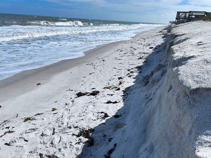
I had some business in Vero Monday, so I stopped at the beach.  I quickly realized that I forgot to pack my equipment.  At least I got to take a look and take a couple photos.

You can see the cliff from the past erosion, but there is still a lot of renourishment sand in front of the dunes

You can also see a little seaweed that has washed up.  That is a common sign of east swells pushing stuff up onto the beach.  


Turtle Trail Monday Early Afternoon.


We now have a storm named Rafael.  Expected to become a hurricane soon, it looks like it could pass not far off the Keys and head up through the Gulf.


We are still having some really nice high tides.  And the surf is big too.  If you look around or have been following the beaches closely, you should have some good spots to check today.

Referring to my old rating scale, I'd call this Level 2 or transitional conditions.  Although the angles aren't good, there is some chance.  It depends upon how much effort you have put into monitoring the beaches.


Source: Surfguru.com.

I'd like to get out, but don't know if I'll manage today.

It is voting day.

By the look of the lines at the polling places, the only people that will be able to vote today are those who have nothing else they have to do all day long.  Talk about voter suppression.

Good hunting,
TreasureGuide@comcast.net

Monday, November 4, 2024

11/4/24 Report - Another Gulf Hurricane Forming. A Little Hillbilly Hunt. Private Property and Property Lines.


Written by the Treasureguide for the exclusive use of the Treasure Beaches Report.

Source: nhc.noaa.gov.

Looks like there could be another hurricane forming.  And it looks like it could go up through the Gulf  I'm talking about the red x.  Below is what the National Hurricane Center shows for it.


Soure: nhc.noaa. gov.

As you can see, it could become a hurricane but might weaken to a storm before making landfall.


Source: Surfguru.com.

We are still having some really good high tides, and according to Surfguru.com, we'll have some more high surf this week.  Problem is, the angles still don't look great.

---

A couple days ago I showed my Garrett Ace metal detector with a rod assembly of scrap wood and duct tape that I took on a trip.  I recently used the detector on a couple little hunts in the West Virginia wooded hills.  The ground was rock hard and the area had been covered by detectorists many times before, so I didn't expect much but thought there still might be a chance of coming up with something nice and old.  

It took forever to dig each and every target with the hand trowel that I had, and I didn't have a lot of time to hunt anyhow.  I wish I would have had cleats to help me hand onto the steep slope of the hills, but I only had an old pair of old worn-out slick sneakers.  Nonetheless, I had a little fun.  I was surprised to find several modern coins.  There was a lot of junk aluminum, so all of that made it difficult to get the few older coins that I thought might still be buried near or beyond the range of the Ace.

I don't always have to have the best or most powerful detector.  I have fun with something like an entry level detector and always believe that there is always something to be found.

Here are a few of my finds.  

A Few Finds.
Figure, Small Lock or Charm, Rolled Lead, Bullet and Some Coins.


Once again, I found there is always still something to find.

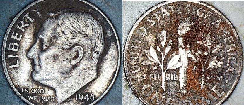
Below is a 1946 dime, which was the oldest of the modern coins.  It didn't even require cleaning.  Some of the other clad did require cleaning.


Silver Dime Find.

The dime came out of some very hard ground.  I was surprised to find it in such good condition.

---

The above finds came out of the forested hills of West Virginia.  Like many of my Florida finds, they came from private property.   

As you know, you should get permission from the owners if you hunt on private property, but it is not always easy to know where the property lines are and therefore who owns the land.

There is a good chance you've found some things on private property without knowing it.  That could easily be the case on the Treasure Coast beaches.

Along the Treasure Coast beaches there are many homes as well as businesses behind the beaches.  You can see the homes, but do you know where the line between the private property and public beach is?  Usually you don't know exactly where the property line is.  In many cases, the property line will be towards the back of the beach but in front of the face of the eroding dune.  If the beach has been renourished, the property line has a better chance of being behind the dune face.  In many cases the survey markers will be buried.

Besides private homes, the area behind the beach can be owned by a corporation, such as Disney or FPL, or a HOA or condo association.  In some cases, you will see No Trespassing signs, but you still won't know exactly where the property line is.  The trespassing signs may not be right on the property line.  

The dividing line will often be at the Mean High Water Line, but it is nearly impossible to know exactly where that is.

I found a good article about that.  It is clear and not too technical.  Below is an excerpt.

Let's start with a definition of the Mean High Water Line (MHWL), an important measurement when it comes to beachfront property lines. Florida Statutes 177.27(14) and (15) establish the MHWL as the average height (elevation) of high tide saltwater at a specific location on the shore over a 19-year period. Most of us who go to Florida beaches think of a high-tide mark as how far water comes onto the beach (distance) at high tide on any given day. Same basic concept, just different ways to look at it.

The MHWL measurement uses an average because beach sand and bottom contours change every time the tide goes in or out, and definitely whenever a Hurricane makes landfall. It is usually just surveyors who deal with the technical MHWL, which can be very difficult and involved to precisely locate. 

Here is the link.  (Source: Who Owns The Beach In Florida? And Why Does It Matter?)

People often talk of the wet/dry sand rule, which in reality is virtually meaningless in this regard.  As the article explains, the wet sand line constantly changes, while the Mean High Water Line changes on every 19 years or so.

The situation along the intercoastal waterway is similar.  The water level changes, and the banks erode, but that does not determine the property line

If you find something on the banks of the intercoastal, there is a good chance the item was found on the private property of the home or business behind the bank.  You can occasionally see survey markers sticking up out of the mud or water along the banks of the Lagoon.  In some cases, the survey markers are old and out-of-date.  Without seeing the survey markers, it is nearly impossible to know where the property line is.  

Many properties along the intercoastal extend down the bank to the MHWL and A1A goes through the property.  Many people seem to think that the property lines end at the highway, but in some areas they do not.

The bottom line is that property lines can difficult to determine precisely and finds may be made on private property when you do not know it.

---

Good hunting,

Treaureguide@comcast.net


The same ambiguity exists along the intercoastal waterway.  Again the property line separating the waterway that provides access to the public for recreational activities and private property will not always be well marked.  Along the intercoastal, you will sometimes see survey markers sticking up near the waterline, but in more cases the survey markers will not be easy to find.  

To make matters worse, those lines will change along with the Mean High Tide line.


The Treasure Beaches Report Direct From Florida's Treasure Coast.: 9/17/14 Something Different. Life Is A Beach or Me and Dad. Not a Beach Report.The Treasure Beaches Report Direct From Florida's Treasure Coast.: 9/17/14 Something Different. Life Is A Beach or Me and Dad. Not a Beach Report.

The Treasure Beaches Report Direct From Florida's Treasure Coast.: 9/17/14 Something Different. Life Is A Beach or Me and Dad. Not a Beach Report.The Treasure Beaches Report Direct From Florida's Treasure Coast.: 9/17/14 Something Different. Life Is A Beach or Me and Dad. Not a Beach Report.

===

We usually talk about the beaches and assume that everything found is on public property, but it isn't as simple as that.  The property lines for private waterfront properties can extend out beyond the dune face, which people often look at as the property boundary.  It might look like he property line, but it is not.  Sometimes you can find property markers that are determined by survey, but often they will be buried and invisible.

I've talked about the mean high tide line before.


Does The Property Line Move When The Shoreline Changes at my Waterfront Property?


José Maria da Fonseca Winery: A Toast to Tradition and Innovation - The Lisbon Guide - Updated 2024


Saturday, November 2, 2024

11/2/24 Report - Gold Votive Plaque. Excavated Dagger. Long Handle Duct Taped Detector. More High Tides.


Written by the TreasureGuide for the exclusive use of the Treasure Beaches Report.

Gold Votive Plaque Excavated at Roman Fort.


Archaeologists have uncovered a "unique" gold artifact dedicated to an ancient deity at the site of a Roman fort, hinting at the existence of a lost temple.

The votive plaque is among the "most important" discoveries revealed by excavations conducted this year at the Roman fort of Apsaros in Georgia—a country that straddles the boundary between Eastern Europe and West Asia in the Caucasus region—Radosław Karasiewicz-Szczypiorski...

The votive plaque found during the 2024 excavation season at the site, which ran from mid-May to the end of July, is essentially a thin gold plate. It features a Greek inscription dedicated to Jupiter Dolichenus—a deity worshipped in the Roman Empire who was particularly revered by soldiers. The deity combined aspects of the Roman god Jupiter with an ancient Near Eastern storm and fertility deity worshipped at Doliche in what is now southeastern Turkey.

Here is the link for more about that.

Unique' Gold Artifact Discovered at Roman Fort Hints at Lost Temple - Newsweek

---

Excavated Copper Age Dagger..


Archaeologists have unearthed a rare dagger dating back to the Copper Age at Tina Jama Cave in the regional decentralization entity of Trieste in the Italian region of Friuli-Venezia Giulia...

“Such finds do not have exact parallels in Italy, but the Tina Jama dagger can be compared with similar finds from the famous Dežman/Deschmann pile dwellings near Ljubljana in Slovenia,” Professor Bernardini said.

“Excavations at Tina Jama uncovered layers from the Bronze and Final Copper Age, dating back to the second half of the 3rd millennium BCE,” added Dr. Elena Leghissa, an archaeologist at the Institute of Archaeology of the Research Centre of the Slovenian Academy of Sciences and the Slovenske akademije znanosti in umetnosti.

Here is the link for more about that.

Archaeologists Find 4,000-Year-Old Copper Dagger in Italy | Sci.News

---

I took a trip and wanted to have a metal detector along, but just wanted to stick the detector in my gym bag so I just took the coil, two lower rods, and control box.  I didn't take the upper rod with arm rest.  It was too bulky.  So when I got where I was going, I added a wood extension and used duct tape to attach the control box to the extension.  The extension was just a piece of corner molding.


It worked well enough.  The longer handle was easy to swing and use.  It fit under my arm and was actually easier to swing and handle than the stock rod with the arm rest.   And additionally, it allowed me to reach farther, which was handy in some situations, for example reaching under bushes or up a steep bank.  Overall, I was pleased and was able to make finds.

This shows the duct taped control box.

Duct Taped Control Box.


Just a Garrett Ace that did the job.  I didn't want to take a top-level detector. Just something that worked under the circumstances.

----


Source: SurfGuru.com.

Still a decent, but not big, surf.  The high tides are still very high though.

Good hunting,

TreasureGuide@comcast.net