Written by the TreasureGuide for the exclusive use of the Treasure Beaches Report.
SeaSearcher drone is set to take the treasure-hunting world by storm. SeaSearcher is an Underwater Metal Detecting Drone (UMDD).
The vehicle's big claim to fame is that it can detect – and differentiate between – various types of metal buried up to 10 meters (33 ft) beneath the seabed, creating and relaying a 3D digital map of their location...
In a field test recently conducted at a Florida wreck site, the SeaSeacher didn't find any gold or silver, but it is claimed to have identified brass, iron, copper, aluminum, lead and stainless steel items.
The geographical location of the detected metals is determined in two ways. First of all, since radio waves don't travel well through the water, the SeaSearcher tows a floating buoy along the surface above itself. The GPS coordinates of that buoy are recorded and transmitted to the crew, aboard a nearby support boat from which the SeaSearcher was launched...
https://newatlas.com/drones/seasearcher-treasure-hunting-drone/
---
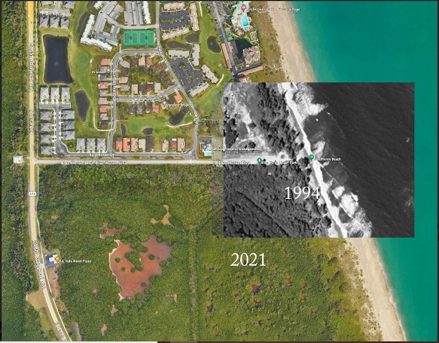
Below you can see the north end of John Brooks and the area just north of that. Alberto S. captured this Google Earth image because yesterday I mentioned those areas, as I remembered them.
 |
| North End of John Brooks and North of That as captured by Alberto S. |
For comparison, Alberto added a section as it looked in 2004 - the year of hurricanes Frances and Jeanne.
 |
| 2021 Google Earth Image With 2004 Image. |
It looks like the waterline was farther back when this image was made, as was the vegetation. It looks like the turnaround at the end of the road just south of the condos was covered with sand. That would probably mean it was after one or both of the hurricanes.
The old parking lot at Blind Creek, which was just south of the current parking lot, frequently got filled with sand after high water. They always had to get heavy equipment to clean it out. I think it was after the 2004 hurricanes that they closed it for good.
 |
| 2021 Google Earth Image With 1994 Image Overlayed. |
It looks like the water was pretty rough when the 1994 picture was taken, and the water was even farther back, but the turnaround was not covered. It looks like the wash was getting almost to the circle. These days there is a lot more distance between the circle and the water line. The sand has been accumulating there a lot in recent years.
Thanks again to Alberto.
---
Will somebody please help Joe?
PARIS on Twitter: "Oh boy. https://t.co/uG4ah3tNDt" / Twitter
Thats the same guy that got more votes than anyone ever. Now where is everyone? Sheeesh.
----
Still some chance of cyclone development being shown on the NHC map.
 |
| Source: nhc.noaa.gov |
I don't see any changes significant in the surf predictions. Still a small surf.
Good hunting,
TreasureGuide@comcast.net
