Search This Blog

Tuesday, September 20, 2022

9/20/22 Report - Hurricane Fiona and Big Surf Predictions. Well Preserved 16th Century Shipwreck Discovered. Living History.


 Written by the TreasureGuide for the exclusive use of the Treasure Beaches Report.

Source: See link below.


New excavations have coaxed more secrets from Gribshunden, the flagship of the Danish-Norwegian King Hans which mysteriously sank in 1495 off the coast of Ronneby, Sweden. The wreck is internationally significant as the world’s best-preserved ship from the Age of Exploration - a proxy for the vessels of Christopher Columbus and Vasco da Gama.

Here is the link for more about that.

Cutting edge science reveals Graubünden’s shipwrecked secrets | Lund University

---

Source: MagicSeaweed.com.

MagicSeaWeed.com is predicting a five-to-eight-foot surf for Friday.  I think there is a decrease in the predicted surf for Thursday.  I don't like to see that and hope it doesn't end up extending into Friday.

What I like is the predicted bigger surf and the predicted northerly wind direction.  What I don't like is direction of the primary swell and the wind direction.  While the wind seems to be from the north a good bit of the time, it is also expected to be from the west for a short time, and it doesn't look like it will result in a good angle for the primary swells.

Still, it is good to get a higher surf.   It is certainly more encouraging than all the one- or two-foot surf that we had most of the summer.  I'll be checking to see how these predictions hold up and what actually happens.

And don't forget the high level of sand on many of the beach fronts.


Source: nhc.noaa.gov.

---

Living History.

Yesterday I watched a lot of TV.  I was captivated by the Royal proceedings.  There was so much history on display, but also many bright examples of the human condition.  In contrast to much of what goes on today, you could see what humans can accomplish.  There were cathedrals with enchanting architecture and great art on display.  Without modern machinery, the most amazing structures were built.  It is hard to imagine the genius, but they did it.  Humans are capable of so much good as well as evil.

On display also so much history, sociology, art, culture, as well as sociology and psychology.  I know there are those who saw nothing good in all that ceremony.  Some people see the positive side of things, while others see the negative, and some see subtle mixtures of both.   Also maybe there was some objectivity, or dasein (being there), letting the world appear without recasting it in our own image - letting it appear and amaze us.  What an incomprehensible, amazing miracle it is to simply be alive and awake.

We saw the Queen and the royalty.  You can see that as being something wonderful or as a travesty of unearned privilege and the fruits of ill-gotten gains.  But aren't we all guilty?  Why was I born with two functional arms and legs and a decent working brain and parents who took care of me, when others do not live past one day, or live years with debilitating disabilities?  There is the lottery of the human condition that at times overwhelms the struggle for self-determination.

Those most happy, I suppose, are those able to share in the good fortune or others.  Those are the same peple that count their own blessings as innumerable.  Others burn in the torment of their own discontent and try to cast their torture on others.

I am happy to be king of my own domain and attempt to shape and color it so some extent.  I was lucky to be raised moderately poor.  I didn't know we were poor.  My world back then was small, which made it easy to grow and appreciate small things.  My parents did well.  That is how I see it, though my sister sees it otherwise.  Just goes to show.

I've had much luck in life, more than deserved, I'm sure, and don't have many complaints at all, though I wish some things were different - as do the royals.

But when it comes down to it, in watching the ceremonies, we saw, or at least imagined, something of ourselves - our humanity and mortality.  We saw ourselves in many varied facets.  As rulers of our own domain; as victims of our circumstances; as mourners; as young and aged; and finally, as mortal.  And recognize it or not, there goes I, naked into the world, and naked again, to what God has prepared for us.

---

Keep watching Fiona.

TreasureGuide@comcast.net

Monday, September 19, 2022

9/19/22 Report - Hurricane Fiona's Likely Path and Effects. The Treasure Coast Beach Metal Detecting Scale Revisited.


Written by the TreasureGuide for the exclusive use of the Treasure Beaches Report.

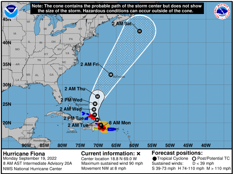
Source: nhc.noaa.gov

There is now hurricane Fiona, but it looks like it will probably stay far to the east.  According to MagicSeaWeed, it will still bring us some higher surf.

Source: MagicSeaWeed.com.

So far it looks like we might get a five to seven- or eight-foot surf.  An eight-foot surf is pretty big, but unfortunately, we are now having tides that are nearly flat, which will moderate the effect of the surf.

Predicting erosion depends upon other predictions when you attempt to do it a few days out.  Once those factors are firm, your erosion predictions can be pretty accurate.  Of course, the weather models contain some degree of uncertainty and disagreement, and that adds to the amount of uncertainty to any predictions of erosion.

---

When I started this blog, the primary purpose was to let people know what to expect of beach metal detecting conditions, and I reported on beach conditions every day. 

I began metal detecting in South Florida and mostly hunted modern jewelry, but eventually started making occasional trips to the Treasure Coast.   Often after the drive, I'd arrive only to find the beaches totally sanded in.  Remember, that was before there was so much on the internet.  I started this blog and posted beach conditions ratings so people wouldn't have to make so many wasted trips.  The blog evolved as I started to post finds and other thoughts about metal detecting and whatever I felt like writing about.  There were times, especially during summers, when beach conditions remained the same for so long that I got bored with posting the same rating every day.  I then started giving my beach conditions rating only when something was happening. 

When I began this blog, I didn't know if anyone would read it, but it quickly took off.  Hundreds of people were reading each daily post.  

People ask how I find something to talk about every day, but there is always something on my mind to post.  By writing down my thoughts, it forces me to be more clear and precise and that helps me refine and develop my ideas, which is how I benefit from doing this blog.  

Anyhow, yesterday I wrote about the subject of predicting beach erosion, and I mentioned my beach conditions rating scale, which I haven't posted much lately.  This summer we had very little surf and almost no changes in beach metal detecting conditions.

I thought it might be helpful to go back and revisit my rating scale, which evolved over the years.  The rating scale is a five-point scale.  A 1 rating indicates poor detecting conditions, and a 5 rating indicates excellent beach detecting conditions.  The rating scale provides an idea of how likely it is that old Spanish Treasure coins will be found.  It does not attempt to predict other types of finds.

Level 1 conditions are very common, while level 5 conditions are rare.  Level 1 conditions are conditions of accretion or no change (which must be something like 60% of the time) while level 5 conditions are those with massive erosion such as occurred during the Thanksgiving Storm of 1984 or the storms of 2004.  During those times erosion develops or remains for a period of days, creates big cuts, and removes significant sand from the back dunes.

One of the difficulties with my rating scale is that it is an overall rating for the Treasure Coast and does not describe individual beaches.  There can be times when only one or two beaches are good, while the others do not improve or do not improve nearly as much.  That is not so much the case during level 1 or 5 conditions, but when there is a more moderate rating, there can be more variability between beaches.  I have to kind of average it out, so if you visit the wrong beach, you will get the impression that the rating is wrong.

Below is a little chart I find useful.  The vast majority of good finds are made on very few days.  If you've experiences some very productive days, you know they aren't real common.  When things are hot, they are hot.  When they are not, they are not.  During more moderate conditions, unless you hit just the right spot, you will not get that many finds.

A "2" rating on my scale, indicates transitional conditions. It indicates that sand has moved and while there is a slight chance of good finds being made, there might well be none, and if there are any, they will be very few.

A level 3 rating indicates that finds will almost certainly be made, but they will not be very plentiful.

A level four rating indicates that finds will be common.

I've already described level five.  There will be massive erosion to most beaches, including big cuts and significant erosion to dunes.  You might have one of those only every few years.  During level five conditions, beaches and bridges might be closed.  

Not everyone will be successful when beach conditions improve, no matter what the rating is.  You still have to make finds.  If you visit the wrong beach at the wrong time and miss out, you might think the rating is wrong.  Skill and luck still matter.

Occasionally only one beach will be producing and you will miss out unless you happen to hit that particular beach.  That was the case once in 2020, for example.  When that is the case, I don't like to name the particular beach because everyone will flock to that one beach.  And during those times, since I don't get to go out a lot anymore, I can easily miss those myself.  People do not share as much anymore as they did a few years ago.  Nevertheless, giving some idea of overall beach conditions helps a lot of people and prevents a lot of wasted trips.  You'd rather go out when there is some chance than none.  It is a matter of probabilities. The general information provided by the beach conditions ratings should help.  When it comes down to it, you have to make your own decisions, but you will be better off if you learn to take advantage of the freely offered information.

Recent beach renourishment made it difficult for all of us.  You could get a lot of erosion, and still the beach would not be productive.  That kind of thing increases the variability between beaches.  As I've said before, not all erosion is the same.  Erosion to a newly renourished beach won't help much unless the amount of erosion is huge.

---

Good hunting,

Treasureguide@comcast.net


Saturday, September 17, 2022

9/17/22 Report - Predicting Beach Erosion and Beach Conditions. Bigger Surf Predicted.


Written by the TreasureGuide for the exclusive use of the Treasure Beaches Report.

s
Walton Rocks Beach Friday Near Low Tide.

I ran into a discussion about if beach erosion could be predicted..  Since the discussion was between detectorists, I assume that is not the question they were really interested in.  I think what they really wanted to know is when they could make good finds - not when there would be erosion.  The first thing you have to do is ask the right question.  

Erosion and metal detecting beach conditions are not exactly the same thing.  You can have big erosion and no finds, or you can have very little erosion, but be able to find good things.  Predicting erosion is only one part of the problem.  It would take me quite a while to explain all of that, but I will give one quick example now.  You can have big erosion on beaches like those right after the beach renourishment in the Vero area but still not get good finds.  Not all erosion produces good metal detecting finds.  It depends not only on the amount of erosion, but the previous state or condition of the beaches. You can have huge erosion and no finds, simply because there was nothing there to start with. It helps to ask the right question.  Are you really interested in erosion or are you interested in the probability of making finds.  Again, there is some correlation, but they are not the same things.  \

Big erosion can actually wash away coins just like it can wash away sand.  If you watch Gold Rush on TV, you know that too much water through the sluice box will wash the gold away as well as the sand.  Predicting erosion is not the same thing as predicting beach conditions, although predicting erosion is part of the problem.

Here is one article that will facilitate this discussion.

Predicting beach erosion. - Free Online Library (thefreelibrary.com)

Here is an excerpt from that article.

But the model [Bruun rule] does not take into account the enormous complexity and uniqueness of natural environments, according to Orrin Pilkey of Duke University and Andrew Cooper of the University of Ulster.

Predicting erosion involves a lot of factors and beach environments are unique and complex.  Predicting erosion, if that is really what you want to do, is complex, but we have accomplished it to a large extent.  

I quit giving my beach conditions rating not because it didn't work, but because much of the time beach conditions were too predictable. Take this summer.  This summer on the Treasure Coast, you would have been correct most of the time if every day you simply said beach metal detecting conditions are poor today.  It was a long summer with almost no significant erosion.  The surf was running one or two feet most days and the beaches had just received tons of renourishment sand.  There was erosion, but those days were few and the erosion was not significant even though there was a lot of it because there was so much sand to start with.  Big erosion during times when there is way too much sand to start with is more likely, but not significant.  Renourishment sand is easily eroded for various reasons. (I should add that eroding renourishment sand can produce finds if good things were in the sand that was dumped on the beach.).

Here is another excerpt from the same source.

Unfortunately, the alternative to the Bruun rule, extrapolation of past beach behavior, also has problems: Past data may be incomplete, and different parts of a single beach may erode at different rates.

Knowing past beach behavior will help the detectorist, but that is difficult, if not impossible, to quantify.  And it is true that different  parts of a beach can erode at different rates.  I've said that many times.  Sand can move one direction or another.  One part of the beach will be eroded while another nearby part will accrete.  The sand can move north/south or east/west.  The front beach can erode, while the high beach remains untouched, or the sand from the high beach can be washed down and dumped on the front of the beach.  This can happen to large areas and amounts of sand or much smaller areas and smaller amounts of sand. 

You are not starting with a static beach.  Some changes are long term, taking years or decades, while other changes are short term - taking weeks, days, hours, or even minutes.  I've seen a mid-beach cut washed away in a few minutes.  When talking about erosion, you are probably talking about relatively large changes to a continually changing beach.  I've said many times how important it is to know the history of the beach, including where it was and how it changed in the past.

If you look at the picture at the top of the post, it looks very eroded, doesn't it.  It eroded, but only a few inches in the last three days.  This beach was producing old things back a year or two ago.  It got more sand, then less sand, and then more sand, over and over for the past year or two.  The lowest part (most eroded spot) moved north and south several times as well.  So, is this beach eroded?  Yes, but most of the erosion was not recent.  The recent erosion, due to Earl, was minor and there was a time a year or two ago when much more significant erosion occurred, and beach conditions were much better.

Not all erosion is the same.  How do you quantify erosion?  Amount of sand lost?  In my opinion, that is not the most relevant thing for the detectorist.  The detectorists really wants to know when he can find good targets.  Again, that is not the same thing as the amount of erosion.  Where the erosion happens, and when it happens, are important factors.

Erosion to the front or mid-beach might be productive, but only if it is in an area where desirable targets can be found.  A beach that erodes three feet deep, may or may not produce good targets.  If the good targets are under four feet of sand, two feet of erosion won't get you there.  If the same beach was eroded four feet in the past, fills up again, and then erodes two feet, it likely won't get you there, but it could, depending upon a variety of factors.  One interesting thing about dune erosion in good areas, is that the eroded targets can end up right on top of newly accreted sand near the base of the dunes.

So, can beach erosion be predicted?  Yes, but not perfectly.  It is very much like predicting storms, which have also become more accurate in the past ten years or so.  They are more accurate, but there is still some uncertainty.  The same thing is true of surf predictions.  It seems that the MagicSeaWeed predictions have improved.  Not many years ago there was an obvious error in the model.  When a big surf was predicted seven days out, a lot of the time that big surf prediction would decrease or disappear.  That doesn't seem to happen nearly as often now.

In my opinion. beach erosion predictions are pretty accurate now. Not perfect, but pretty good, You can't predict for every part of the beach though.  One part will erode when another part does not. There is always some erosion somewhere.  The question should be more specific. Erosion is local and may or may not be signficant for the detectorist in the areas of interest.  On top of that, the detectorist must be in the right place at the right time.  A detectorist can be off by an hour or less or a foot or less.  There might be erosion at one place that produces good finds, and the detectorist can simply be at the wrong place at the wrong time.  In fact, he might walk right over a good target and miss it because of poor technique or equipment and conclude the predictions were wrong. 


And erosion is not always easy to identify.  There can be very significant erosion that does not produce any cut at all.  The entire slope of the beach can change, and that might not be obvious but still be very significant.  I've talked about those things before.

In my 9/9 post I said, "As you can see, Walton Rocks Beach is low and wide.  It has been down for quite a few months."  I showed a photo of Walton Rocks as it was on 9/9.  In the same post I showed a photo of John Brooks.  The two beaches were very different.  Brooks was built up, while Rocks had lost a lot of sand over the past year or two and was low and firm.  

In my 9/13 post I said, "Yesterday there was some movement of sand on beach fronts which were at a good angle.. This wasn't a lot of sand moving, but in areas where the sand was already low, could be significantSo it will help if you know the beach angles, and where the sand is low or built up a lot.

At Walton Rocks, the sand was low.  It was renourished back some years ago but had been losing sand for years.  Of course, there were times when sand was added and lost again and again, but the general trend in recent years has been sand loss.  A big event occurred when we had a big surf combined with big tides back in the Fall of 2020, I think it was.  It hasn't recovered significantly since then.  

The rocks shown in the photo above were visible back in (2020 I think) and from time to time since then.  They provide a good measure at that spot.  In 2020 the dune face was hit good and eroded.  In the past week or two the water only barely touched the foot of the dunes there.  The erosion to the slope has been progressing back towards the dunes very slowly in a step-by-step fashion.  

That beach looks very different from John Brooks, for example, where even a few feet of erosion is much less significant.  So my point is that the beginning state of the beach is an important factor - not just the recent erosion.   And the angle of the beach and waves will erode one beach while not another.   A foot of erosion might be significant at one place but not at another.  It gets pretty complex, but you need to know the beach, the current state of the beach, the history of the beach, and the various areas of the beaches.  An inch of erosion at one beach can be worth a foot of erosion at another.

So, can we predict erosion?  I'd say we can predict it fairly well, but not 100%, just like with storms. We knew all summer long there was going to be little erosion, and there was little, and when there was some, it wasn't very productive for the detectorist because it was mostly in renourishment sand.

Productive erosion for the metal detectorist is a relatively rare event.  Since the Thanksgiving storm of 1984, we've had only a few similar events - 2004, for example. 

When I was doing my beach conditions ratings on a regular basis, it was not often that I was able to give a 3, 4 or 5 rating.  Most of the time it was a 1 or 2, which got boring.  Only a few times a year do we get an overall improvement in beach conditions.  You can go out and find some modern coins or jewelry any day and have some chance of finding something old if you hit just the right spot at the right time but finding treasure coins on the beach is a relatively rare event.  How many times a year do you find treasure coins.  It doesn't happen every day, or even every month.  But you don't want to miss it.  My polls showed that if you found one, you probably found more than one.  When it is hot, it is hot.  

Back to the question of predicting erosion.  I think it is pretty good.  I'm seldom surprised by what I see when I go to the beach.  It happens.  I missed one erosion even about a month ago, but I'd say I'm at least 90% accurate.  

If you take into account the surf height, wind and swell direction, tides, and very importantly the shape, history and condition of the beaches, you can predict erosion fairly well.  First of all, if you only have a one- or two-foot surf, as we had most of the summer, you are not going to get significant erosion no matter what else is going on.  Once you get up to five or six foot surf, it gets questionable, and then you have to consider other things, such as the angles and tides.  You also have to consider, though, the state or condition of the beaches.  A lot of sand in front of the beach can protect the beach from the force of water. so that kind of thing also has to be considered.

Once again, whether erosion results in finds is another question and involves other factors.  It can also be confined to small areas.  While most of the beaches are poor, you can get individual beaches or smaller areas of individual beaches that produce.

I'm sorry that wasn't more commplete and better organized, but I hope that discussion helped some.

---

Funny that the rich liberal elites (black, brown and white alike) in places like Martha's Vineyard who are all for illegal immigration won't open their grounds and guest houses for the poor people.  Just like energy.  They'll fly private planes while you are supposed to walk or ride a bicycle.  The elites safely maintain power as long they keep the common folk against each other.  

---

Source: nhc.noaa.gov

The NHC is still showing Fiona staying out east of the Bahamas.


Source: MagicSeaweed.com.

Looks like we might get some bigger surf next week.  Watch to see how that develops.

Good hunting,
TreasureGuide@comcast.net

Friday, September 16, 2022

9/16/22 Report - Treasures of Pirate or Privateer Louis DeAury. Plugged Cannons. Gem Vault. Fiona.

 Written by the TreasureGuide for the exclusive use of the Treasure Beaches Report.

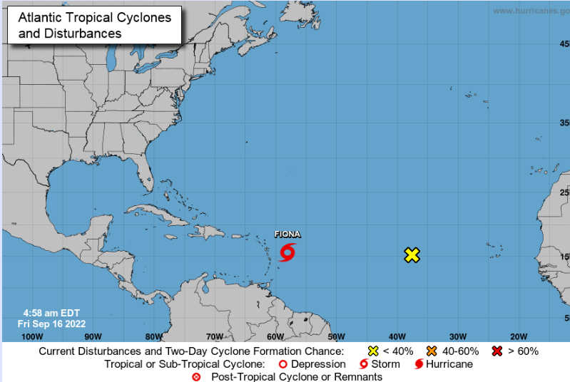
Source: nhc.noaa.gov.


Tropical storm Fiona is now headed towards Hispaniola, but expected to turn north shortly after that.


In the surf predictions, there is a hint of a higher surf out about seven days.  Keep watching.

The tides have moderated some.

---

Did you ever hear of Louis DeAury?

One scoundrel Pirate who spent time on Amelia Island was born Louis Michel Aury. Though he claimed to be Mexican, Louis Aury was born in Paris around 1788. As a young man he served in the French Navy, and then preyed on French Privateers, saving a small fortune and then setting sail as master of his own vessels...

Within the year, Aury resigned his post and headed to the Florida coast joining Gregor MacGregor. MacGregor was an authorized agent of the rebel colonies now known as Venezuela, Colombia, Mexico, and Argentina. MacGregor was financed by US business firms to capture Fort San Carlos taking over control of Amelia Island and away from the Spanish. As MacGregor ran out of money for men and munitions, he left Amelia under the care of Ruggles Hubbard and Jared Irwin, who by a fluke, were able to repel a Spanish counterattack in the Battle of Amelia in 1817.

Here is a bit more about Aury (or Auri).

AURY, LOUIS MICHEL (ca. 1788–1821).Louis Michel Aury, pirate, was born in Paris about 1788. He served in the French navy and on French privateers from 1802 or 1803 until 1810, when accumulation of prize money enabled him to become master of his own vessels. He sailed from a North Carolina port with a Venezuelan commission in April 1813 and reached Cartagena in May. In August 1813 he was given command over the Granadine Republic's privateer schooners, a service that ended in January 1816, when he reached Aux Cayes, Haiti, after successfully running the Spanish blockade of Cartagena...

Here is the link for the rest of that article.

Pirate Louis Aury Raised the Mexican Flag Over Amelia Island | (searchamelia.com)

I started to write about this several days ago, but got redirected by some other things. 

DeAury apparently spent a good bit of time on the west coast of Florida.  Frank Hudson referred to his treasures several times.  For example, Hudson says DeAury buried one chest, and maybe more on Dutchman's Key.  He also refers to Aurytown, which he describes as a pirate ghost town where DeAury "had his headquarters."  That was on Honeymoon Island.

Also on Honeymoon Island, according to Hudson, were two plugged canons filled with loot, but, those were buried by Lafitte, not DeAury.  Other pirates treasures mentioned for Honeymoon island include a "jewel vault" made by Blackbeard.  

But back to DeAury - Hudson mentions chests buried by a freshwater spring where ships watered and which gave Clearwater its name.  The chests were described as being "under Clearwater city street."

Here is more about DeAury from the Texas State Historical Association.

TSHA | Aury, Louis Michel (tshaonline.org)

---

Last night, as is often the case, I awoke from a dream.  In the dream, I was back where I spent my childhood.  My wife was with me, though she had been there only once.   A model train layout covered acres and acres.  We marveled at it, and there, with us, were the children of an older relative I spent some time with working on his farm. We were amazed by the scene, as young people will be, but then I mentioned that my mom just died, and I began to cry.  One of the children in the dream tried to comfort me.  In real life, their dad died a few years ago.

As is so often the case, when I awoke around 4 AM, I knew the lesson of the dream.  Here it is: the real treasure is the people that are around you.  

We like things.  I always liked model trains.  And we spend time searching for things like buried chests filled with gems and gold.  But the real treasure is those around us.   Moments don't last, but memories sometimes do.

I posted a photo a couple days ago of a father with his metal detector with his little child.  I was told that the detectorist didn't find anything that day other than a couple old nails.  But I think there were precious memories that will be long remembered. 

Moments to Remember.
Photo by Melissa G

Good hunting,

TreasureGuide@comcast.net


Thursday, September 15, 2022

9/15/22 Report - Vero Beaches Very Sandy. Mayan Stone Tablet Found by Accident. Skull In Cave. Fiona Coming.


Written by the TreasureGuide for the exclusive use of the Treasure Beaches Report.


Jaycee Beach in Vero Beach Thursday Afternoon.


I had an appointment in Vero Thursday. I got a few minutes to check a couple nearby beaches. I don't think I've been to the Vero/Sebastian beaches all summer. All that new sand is ugly.

Above is Jaycee Beach. A lot of sand there.


In Front of Beach Access At Turtle Trail.


I had time to visit Turtle Trail.  The first thing I noticed there is the buoy almost in front of the beach access.  Looks like they have still working pretty close to the beach.


Turtle Trail Looking South Thursday Afternoon.

You can see all the renourishment sand.  They planted sea oats out five or ten yards from the old dune cliff.  They will probably get washed away before the coming winter is over.

I was curious how those beaches were developing.  Now I have an idea.

---

A street food vendor's tip led archaeologists to find an ancient Maya capital in a cattle rancher's yard...

The rancher had a stone tablet that had an inscription and a drawing of a Sak Tz'i' king dressed as the Maya storm god.

Golden said the site had been raided by looters in 1960s and many of its monuments were stolen. The owner found the stone tablet in some rubble while working to protect what is left of the site.

"He found it by accident. There's a lucky, lucky rescued object the looters had missed," Golden said.
Golden said the looters used saws and other heavy equipment to cut the off faces of the monuments. The pieces wound up in museums and private collections...

Here is the link for more about that.

Ancient Maya capital discovered by archaeologists - CNN

---


MEXICO CITY (AP) — A prehistoric human skeleton has been found in a cave system that was flooded at the end of the last ice age 8,000 years ago, according to a cave-diving archaeologist on Mexico’s Caribbean coast.

Archaeologist Octavio del Rio said he and fellow diver Peter Broger saw the shattered skull and skeleton partly covered by sediment in a cave near where the Mexican government plans to build a high-speed tourist train through the jungle.

Given the distance from the cave entrance, the skeleton couldn’t have gotten there without modern diving equipment, so it must be over 8,000 years old, Del Rio said, referring to the era when rising sea levels flooded the caves.

“There it is. We don’t know if the body was deposited there or if that was where this person died,” said Del Rio. He said that the skeleton was located about 8 meters (26 feet) underwater, about a half-kilometer (one third of a mile) into the cave system...

Here is the cone for tropical storm Fiona.

I'll be watching this. 

The next few days we'll won't be having much surf.

---

Sometimes I get requests for help on some pretty big treasures, and people ask me to give them a call.
If you want help identifying items, please begin by providing some information via email.  I need background information. I'm not much of a phone person and won't make phone calls until I have good background and have some idea of what I might be able to do.\

---

Good hunting,
TreasureGuide@comcast.net

Wednesday, September 14, 2022

9/14/22 Report - 18th Century Jesuit Silver Ring Found. On To Hope For The Next Storm.


Written by the Treasureguide for the exclusive use of the Treasure Beaches Report.

A surprisingly intact ring dating to the 1700s was found by a Michigan archaeology student on the grounds of an 18th century French stronghold known as Fort St. Joseph. The ring is believed to have been a trade trinket used when southwest Michigan was known as New France, experts say. The fort, about 95 miles east of Chicago, was key part of France’s presence in the Great Lakes region, serving as a “mission, garrison, and trading post” before being abandoned in 1781. Such historic baubles have come to be known as ”Jesuit rings.” “Fort St. Joseph was occupied from the 1680s to the 1780s so the ring could have been lost at any point during that time frame,” according to Erika Hartley, field director and curatorial fellow at the Fort St. Joseph Archaeological Project. “It was most likely manufactured prior to its arrival at the fort, but at this point it is hard to narrow down a specific date.”

Read more at: https://www.charlotteobserver.com/news/nation-world/national/article265297941.html#storylink=cpy

Or Ring dating to 1700s uncovered at French fort in Michigan | Charlotte Observer

There are many old silver rings found on our beaches.  People always wonder if they might be from the wrecks.  According to one of the top salvagers, few, if any, silver rings have been found on the wrecks though.  

Similarly, large numbers of half reales are found on the beaches, but more larger denomination coins are found on the wrecks.   Why the discrepancies?  

I don't know, but one theory is that the inexpensive and small denomination silver was used to pay early salvage participants.  I have no evidence, and don't give much weight to the theory, but it is one idea I've come up with when thinking about the apparent discrepancy.  I don't find it very convincing but can't think of a more convincing theory other than there being no relationship between the many silver rings found on the beaches and the wrecks. 

Half reales might be found more on the beaches simply because they wash up more often, or once dredged up, easily lost in the sand again.


[Added 9/15: I did the above hurriedly and will redo and add additional considerations sometime in the near future.] 

--

Source: nhc.noaa.gov.

As the Treasure Coast surf decreases over the next few days, another system heads in our general direction.  This one is expected to go to somewhere around the Dominican Republic, before turning to the north. 


Expected Wind Speeds for Sept. 22.
Source: Ventusky.com.

According to the model, the closest this system will be is shown above on Sept. 22.  At that time, it isn't expected to be a strong hurricane - perhaps a tropical storm or something close to that.

If the Ventusky model is correct, the system will likely stay east of the Bahamas, however it looks to me like the wind direction might actually be better than that produced by Earl.  There is a lot of time before we find out exactly how this one will develop.

In the mean time, the predictions show a decreasing surf, back down to one or two feet.

Source: MagicSeaWeed.com.

Actually today, it looked to me like the surf was just as high today as yesterday.  Maybe it was just the time of day that I saw it.

Good hunting,

Treasureguide@comcast.net

9/14/22 Report - Higher Surf and Tides Didn't Erode South Hutchinson Island 1715 Fleet Beaches. Mayan Mounds and Artifacts.


Written by the TreasureGuide for the exclusive use of the Treasure Beaches Report.

John Brooks Beach Tuesday Afternoon.

I went out to check a couple beaches Tuesday afternoon to see what the higher surf did.  The water was higher than the day before and reached farther back on the beach.  However, the swells were still hitting the beach straight on and didn't produce any erosion, as is what I expected.  

John Brooks Beach Tuesday Afternoon.

As I said yesterday, the water would have to hit and erode the back dune face or move sand where there was a sufficient angle to the beach.  At John Brooks and Frederick Douglass there are not the same kind of back dunes with a steep dune face like you will see at some of the dune faces up in the Vero/Sebastian area.

Frederick Douglass Beach Tuesday Afternoon.


Frederick Douglass looked very much like John Brooks.  The water had been higher and farther back on the beach than the day before.  Still, no erosion to speak of.


Frederick Douglass Beach Tuesday Afternoon.


Overall, on these two South Hutchinson Island wreck beaches, there were no new cuts produced by the higher surf and tides.  The wave angles were not there.

I only saw one person metal detecting.


I don't know what the beaches are like up in the Vero/Sebastian area.  I haven't been there for quite a while.  Maybe someone will send me some photos.

---

Source: See link below.


Our neighborhood paints an interesting portrait of life in the Early Classic period, which dates from A.D. 250-600. By looking at the styles, forms and decoration of broken pieces of pottery, called sherds, we can determine how old these structures are. Standard residences have walls, plaster floors and a collection of domestic vessels that were used for cooking, serving and storage. We also find agricultural tools made of chert, a type of crystalline rock that resembles flint, and manos and metates, which were used to grind maize into flour...

Here is the link for much more about that.

Exploring an ancestral Maya neighborhood | Illinois

These seem to be more the type of pyramids, or perhaps more correctly mounds, mentioned in the article I talked about a few days ago.

---

Source: MagicSeaWeed.com.

The surf will be decreasing now, but there is another possible storm system that seems to be headed in our general direction.  This one seems to have a better chance of coming close to us.

So far, the surf predictions are not showing any effect on us from that one.


Source: nhc.noaa.gov.

You should be alert to small fossils along the waterline.  I saw a couple yesterday.

Good hunting,

Treasureguide@comcast.net