Written by the Treasureguide for the exclusive use of the Treasure Beaches Report.
 |
| Source: nhc.noaa.gov |
The 8 AM morning update from the National Hurricane Center is in. Looks like Ian will pass north of most of the Treasure Coast. It looks like it will track up towards Cape Canaveral. The models seem to be converging on that track.
This morning the Vero/Sebastian area is having the tornado threats, while South Hutchinson Island is pretty quiet, getting a little rain. Don't overlook the rain, which can erode dunes and uncover some objects.
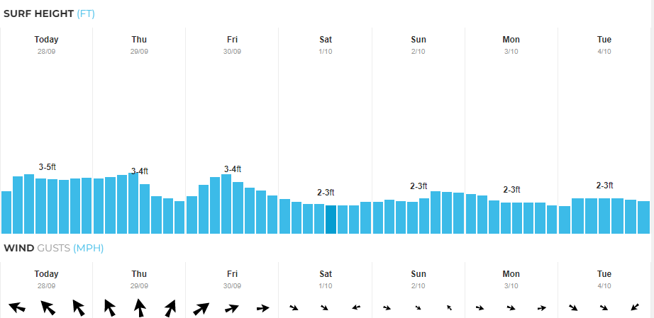 |
| Fort Pierce Area Surf Predictions. Source: MagicSeaWeed.com. |
As you can see, we're not supposed to get a big surf and the wind and swells will be mostly from the south. The Vero/Sebastian surf won't be much different.
The Flagler to Jacksonville area will get some nice north winds and bigger surf. A few days ago I showed an anchor found on Flagler beach. If you are up that way, I'd definitely take a trip out to the beaches there when you get a chance.
If you are in southwest Florida, you'll want to check out the beaches to see where the storm surge has moved sand. Not long ago I did some posts on the coin beaches and treasures of West Florida. Not only might the beaches be good to detect, but they also have some other good hunting, including, but not limited to, shark teeth and shells. If you are around southwest Florida there should be some good new opportunities, but there are more important things to tend to.
Help those in trouble and stay safe. Ian winds got up to 150 miles. Between the high water and extreme winds, there will be a lot of damage and people that need help. Stay safe and do what you can for those who need assistance.
I might be back later today to update this post.
Stay safe,
TreasureGuide@comcast.net