Written by the TreasureGuide for the exclusive use of the Treasure Beaches Report.
 |
| John Brooks Beach Thursday Morning. |
I went out to the beach Thursday morning. As I said yesterday, Lee evidently started to move faster than it had been, and the bigger surf hit the Treasure Coast sooner than was expected a couple days ago.
There was more slope than shows in the photo, and it was pretty mushy.
You might be able to see a little dip just to the north of the access, but it isn't much.
It looked just like I expected. Even though we had a higher surf, sand just got pushed up onto the beach. I pointed that out when I looked at the forecasts, especially the angle east swells, which I talked about despite the north winds. The winds were pretty weak.
Notice the waves breaking at the foot of the beach, suspending sand which would then be pushed up onto the beach.
 |
| John Brooks Beach Thursday Morning. |
 |
| Dunes at John Brooks Beach Thursday Morning. |
I then visited Walton Rocks to see what the beaches looked like down there.
 |
| Walton Rocks Thursday Morning. |
Walton Rocks looked very slightly better than John Brooks, but there was still a lot of renourishment sand. You can see where the waves were breaking on the other side of the dip.
 |
| Walton Rocks Thursday Morning. |
You can see the breaking waves lined up parallel to the beach.
There were several surfers.
 |
| Surfers At Walton Rocks Thursday Morning. |
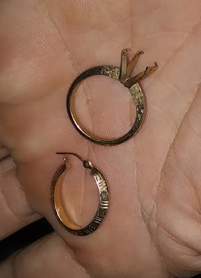
There were a few coins and a couple sinkers and the following items.
 |
| One Ten Karat Earring and One Junk Ring With Missing Stone. |
 |
| SurfGuru Surf Chart for Fort Pierce Inlet Area. |
 |
| SurfGuru Surf Chart for Vero Pier Area. |
As Lee moves north, we'll have a couple more days of nice size surf, then our attention will turn to the newer systems developing in the Atlantic.
 |
| Source: nhc.noaa.gov. |
Good huntng,
TreasureGuide@comcast.net
