Search This Blog

Wednesday, September 30, 2020

9/30/20 Report - How Things Change! Big Metal Detector Companies Going Out of Business.

Written by the TreasureGuide for the exclusive use of the Treasure Beaches Report.


1997 White's Metal Detector Advertisement

If you don't stay ahead, you become the behind.

I just came across a letter from Ken White of White's metal detectors announcing that they are shutting down manufacturing at their Sweet Home facility.  Here it is.


To our valued White’s Dealers-

This is a very difficult message to write, but the time has come for retirement from White’s Electronics.

We are suspending manufacturing operations at our Sweet Home facility while we re-evaluate the future of the company. It is never easy to make these decisions, however, we are faced with the reality of intense competition in the industry and ongoing counterfeit instruments coming from China. Lastly, there have been critical material shortages since the Covid 19 shutdown that we now find insurmountable.

All of us here in Sweet Home are grateful for your service. We consider each of you as part of the White’s extended family.

Sincerely.

Ken White.


They aren't the only ones.  I understand that Tesoro has gone out of business too.  Those are two of the big metal detector manufacturer's that fell behind.

Things have changed since I used my first metal detector about fifty years ago.  It was a Radio Shack, I think.  It wasn't much good, and I didn't stick with metal detecting then, but I cam back some years later and really got into it.

My first serious metal detector was a White's that I got from a Sears Roebuck catalog.  You can't get those huge catalogs any more either.   They were the Amazon of the day.

But things change.  

To me it doesn't seem like things change a lot because I usually look more at general principles and the big picture.  Most of the stuff they advertise doesn't matter much to me.  I'm not so much into all the bells and whistles.  I just want something that does the job reliably.  I don't need the machine to do all the thinking for me.  The human brain is much more powerful than any information processing they put into a metal detector.  

Everybody wants deeper.  To me, where you look is more important than that last inch of depth you can get out of a metal detector.  Of course I want some good depth, but there are a lot of other things that are more important, and how you use the detector has a lot to do with how deep you can detect with it.  The metal detector is just a tool.  Your skill in using it is very important.

They are always coming out with new models and the latest and greatest thing.  The full-page ad from a 1997 issue of Gold and Treasure Hunter Magazine, shown above, mentioned the Goldmaster V/Sat and Sierra Gold Max.  I don't remember either of those, and you probably didn't either.  

Coincidentally, I found another full-page ad in the same magazine from the other metal detector company that went out of business.


Full-Page Tesoro AD In The Same 1997 Magazine.

I don't know who designed those ads, but they look a lot alike, don't they?  And who remembers Micro-Max?  Probably only the people who had one.  Not me.


I had a few Tesoro metal detectors in the past - one was a Royal Sabre, another was a Silver Sabre and one was a Stingray.  Tesoro detectors seemed to have a fast reactioin time - meaning you could sweep them fast, and I always found them good at detecting small gold and platinum, but one of the main reasons I liked Tesoro detectors was their Lifetime warranty, but then they started declaring some detectors obsolete, which meant the lifetime warranty wasn't a lifetime warranty.   And I had some old models, which worked fine, but when they needed service and they didn't honor the lifetime warranty, and I never bought another one.

The Royal Sabre had a number of interesting features, including notch discrimination and surface blanking, which it provided before most other detectors had those features.  Because I was mostly a dig everything kind of guy, I never used surface blanking much, but I did use it a few times.  It would filter out larger and surface targets in junky areas.

I had trouble with my Stingray when I got it.  It wasn't grounded properly and I sent it back a few times before they finally sent me a one with the coil hard-wired.  Problem is when Jack was gone, they thought it was a modification I made, which voided the warranty. 

In the same 1997 magazine I found a six-page ad by Bounty Hunter.  I don't know how much good that did, but they are still around.

Garrett had a big ad on the final outside page.  Of course, they are still around, but it seems not as predominant as they once were.  They were advertising the GTAX - not GTX.  

There was also a full-page ad for the Minlab XT 17000 and SD 2000.  Minelab was not the big name back then that it is today.

There was also a small ad by a store offering the Fisher Gold Bug.

I've owned and used metal detectors by all the metal detector companies mentioned today except for Bounty Hunter.

Soon after my first serious metal detector, the White's Coinmaster that I got in the Sears Roebuck catalong, I got a Fisher 1280 Aquanaut, so I could hunt in the water.  I started hunting in the water a lot and that took my jewelry hunting to another level.

After the Fisher 1280 I started using mostly metal detectors that were made by individuals.  They were great.  My first of those was a modified Nautilus made by a Steve Noga.  I think he was in Maryland at the time.  After that I used Aqauasound detectors made by Herb MacDonald. They were very similar to the detectors that Steve Noga made.   Herb is now deceased, and I don't know what happened to Steve.  Those were very good detectors.

---

As I looked through that old magazine I noticed an article on how to systematically sample a creek for gold nuggets.  Sampling is an important and much underappreciaed skill for any detectorist..

---

 XRF analyzers can be used to test coins embedded in plastic holders without removing them.  

https://www.thermofisher.com/blog/metals/can-xrf-technology-produce-accurate-analysis-on-a-coin-in-a-holder/

---


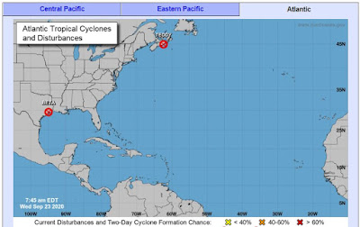
Source: nhc.noaa.gov


There are no new storms, but there is one wave that could develop, and the surf remains around two feet on the Treasure Coast.

Happy hunting,

TreasureGuide@comcast.net


Tuesday, September 29, 2020

9/29/20 Report - XRF Analysis of Gold Escudos. Animals Carried On The Atocha.

Written by the TreasureGuide for the exclusive use of treasurebeachesreport.blogspot.com.

XRF Analysis of Five Escudos - One Suspected of Being Fake.
Source: See nd.edu link below.

It can be next to impossible to determine if some items are fake or counterfeit.  I discovered what appears to be a series of slides from a lecture on the subject.

Shown above is the XRF analysis of five escudos.  There are differences between all five.  The suspect coin has a slightly higher gold content and slight lower silver content.  We are talking small differences though, and I'm not sure the analysis answers the question.  Nonetheless, the comparison does illustrate the usefulness of XRF for determining the content of metals.

 You might be interested in looking at the slide show which shows a few Atocha images as well as some other historic gold treasures.

Here is the link.

https://www3.nd.edu/~nsl/Lectures/phys10262_2014/art-chap2-7.pdfu

If you find the original sources or more complete information on any of the slides, let me know.  Thanks.

---

Horse Restrained For Voyage
Early 16th Century.


Speaking of the Atocha, I also found a study of the animals that were carried on the ship for various reasons.  Many were for food, some were simply unwanted pests, and others, the author thought, could have been taken to Europe for zoos or as exotic pets.  And of course there were work animals, such as horses, but there was no evidence of dogs, which seems strange.

Wild boars, sheep or goats, cattle, turtles and fish were among those use for food.  Since the Atocha sank on only the second day out, few of the animals were eaten during the cruise.  It appears many were eaten on board while the ship was at harbor preparing for the voyage.  Live animals were brought on board last.

That study is A FAUNAL ANALYSIS OF THE 17TH CENTURY GALLEON NUESTRA SENORA DE ATOCHA by Regina L. Chapin.  It is a Master's Thesis submitted in 1990.

Here is the abstract.

The vertebrate faunal analyses of the 17th century sunken Spanish galleons, Nuestra Senora de Atocha and to a lesser extent, the Santa Margarita have yielded relevant information on the transportation of animal types across the Alantic. The collection from the Atocha includes 986 identifiable bones, which mainly consist of various fish, reptiles and mammals, although a few bird bones are noted. Remains were collected from 16 areas either within what was left of the ship, or in sections measured away from the wreck. Evidence has shown that a few animals, namely Sus scrofa and Ovis/Capra, had been consumed during the voyage, due to cut marks and/or burned areas. Fresh fish were also a major food source on board ship. Other species were transported alive for use as breeding stock, curiosities for European zoos, or as commodities. Hence, this assemblage provided important information about human-animal interactions aboard such sailing vessels. 

And here is the link.

https://repository.arizona.edu/bitstream/handle/10150/278482/azu_td_1341464_sip1_m.pdf;jsessionid=D44C0AC6980BAAC0D46CF54F545BBE1B?sequence=1

---

Not long ago I found a couple alligator scutes in the river.  They appeared to be relatively recent.  Just a couple days ago I found an alligator vertebra.  

Alligator Vertebra.

If you saw an image of one of these in an ancient painting, you might easily mistake it for a picture of a flying machine.

---

There are no storms to watch now.

The surf will remain around two feet for at least a few days.

Happy hunting,

Treasureguide@comcast.net


Monday, September 28, 2020

9/28/20 Report - John Newton: Slave Trader and Song Writer. How Currents and Beach Erosion Shape Our Beaches.

Written by the TreasureGuide for the exclusive use of treasurebeachesreport.blogspot.com.

1715 Fleet Cannon
Photo submitted by Jerry P.

This photo was sent to me by Jerry P.  The cannon was listed for sale for $5000.

---

Somebody asked me about the beaches on South Hutchinson Island that have been renourished.  Of course, the beach just south of the Fort Pierce inlet is often renourished.  It seems like they do that one twice a year, but it actually might be more like once a year. 

It seems like Bathtub Beach is always being renourished too.  The sand just won't stay at those places.

The sand has really piled up just south of the condos to the north of John Brooks.  As I've said before, the beach in that area is a hundred or two hundred yards out from where it was once back in the eighties or nineties.

Along the Treasure Coast the predominant long shore currents run north to south, so when the sand is dumped on South Jetty Beach it erodes and gets carried south down to John Brooks and Frederick Douglass beaches.  A lot of it piles up just below the curve at the condos.


Fort Pierce Inlet
Source: Google Earth Maps.


Notice how the beach south of the inlet is cut back.  They keep dumping sand there, but it keeps eroding and being carried south, so when beaches to the north are renourished, beaches to the south will get sand too.


Flow of Sand
 South Hutchinson Island


The inlets along our coast will look like that.  Here is Jupiter Inlet.  Notice once again how the sand builda up north of the inlet, while the sand starved area to the south of the inlet is eroded back.


Jupiter Inlet
Source: Google Earth Maps.


---

You undoubtedly know the song Amazing Grace, but there is a lot of interesting history behind that song.

It was written by John Newton, a former slave trader and slave. His mother died when he was seven, and his father, a seaman, often took him on voyages while he was still a young child.

In 1743, he was captured by the Royal Navy, and he was forced to become a midshipman aboard the HMS Harwich. John Newton tried to escape a couple of times, but every time he was captured and punished in front of a crew of three hundred and fifty members. He was humiliated by the punishment that he wanted to kill the captain. At times he thought of killing himself, but he never did the acts since he would get over the humiliation he faced. Newton was later shifted to the slave ship ‘Pesagus’ which set sail to South Africa. The ship carried slaves and goods to be sold in England. He created a lot of problems in the ship that he was left in South Africa. He was left to a slave dealer known as Amos Clowe who gave him as a slave to his wife who was called Princess Peye who was an African duchess. As a slave, he was tortured and abused just like other slaves who were left in the hands of the Duchess. 

In 1748, he was rescued by a sea captain upon the request of his father. He boarded the ‘Greyhound’ which was a merchant ship that transported beeswax and dyer’s wood.  He spent most of his time reading religious texts and the bible. The ship reached Britain, and there he accepted the doctrines of evangelical Christianity. In 1750, he returned to England where he became a captain for the slave trading ships ‘African’ and ‘Duke of Argyle.’ Newton later stopped dealing in the slave trade...

Here is the link where you can read more about that.

https://www.sunsigns.org/famousbirthdays/d/profile/john-newton/

And another link where you can find additional information.

https://www.learnreligions.com/biography-of-john-newton-author-of-amazing-grace-4843896

So now you know where the words came from - a life of white privilege.  

Here are some of the words.

Amazing Grace! How sweet the sound
That saved a wretch like me!
I once was lost, but now am found
Was blind, but now I see.

'Twas Grace that taught my heart to fear,
And Grace my fears relieved.
How precious did that Grace appear
The hour I first believed.

Through many dangers, toils, and snares
I have already come.
'Tis Grace hath brought me safe thus far

And Grace will lead me home.  

---

No storms and the Treasure Coast surf will be only one foot today. 

I've been forgetting to mention, but my beach conditions rating is back to a 1.

Happy hunting,

TreasureGuide@comcast.net


Sunday, September 27, 2020

9/27/20 Report - Diamonds From a Pig Farm - A Real Life Parable and A Book That Tells You How To Find a Fortune.

 Written by the TreasureGuide for the exclusive use of the Treasure Beaches Report.


Kevin Kinard found a 9.07 carat in the Crater of Diamonds State Park  that sells up to 1000 tickets a day to people who want to search the grounds for diamonds. 

A man who was exploring an Arkansas state park recently came across an unbelievable discovery: a 9.07-carat diamond, making it the second-largest one ever found in the park's history.

Kevin Kinard said he didn't think much of the marble-sized crystal that he found while visiting Crater of Diamonds State Park on Labor Day, according to a press release from the park.

"It kind of looked interesting and shiny, so I put it in my bag and kept searching," he recalled. "I just thought it might’ve been glass."

But after taking it to the park's Diamond Discovery Center, where staff identify what visitors find and register diamonds, Kinard, 33, learned that what he thought was glass was actually a 9.07-carat diamond....

Here is the link for more af that story.


Thanks to DJ for that link.  

DJ pointed out that this story is another case of “if you don’t know don’t throw”.

Below is photo of people searching the park.


Searching For Diamonds at Crater of Diamonds Park
Source: Arkansas.com.

I've posted stories of finds from Crater of Diamonds park before.  The history of the park is interesting.  The story is well-known and has been published in books and articles and has been used for sermon inspiration.

Although not all sources give the story exactly the same way, John Huddleston is sometimes described as a pig farmer, which is not altogether untrue and works well when his story is used as a sermon illustration.  More detailed accounts of his life give a somewhat different picture.

John Huddleston.
Source: See pcahs.org link below.

I'll give the short version as I recall reading it somewhere.  John Huddleston had a pig farm in Arkansas.  One day he noticed a stone shining in the mud.  He picked it up and saved it and eventually showed it to some people.  No one seemed to think much of it, but one man offered him a small sum for the stones.  He had found two by then, and I think the amount offered was 50 cents.  Someone told him to send the stones to New York to be analyzed, and he was informed that his stone was a diamond.  

That is how the diamond bearing area of Arkansas that later became Crater of Diamonds State Park was discovered, or at least that is how it is sometimes told.  Life is always more complex than the way it is described.

I was recently driving to the beach before sunrise when I heard a movie critic on the radio say that no two people "see" the same movie.  Each person looks at different things and takes it in a different way.  

If a movie comes on TV, in the first five seconds my wife will often say, "We've seen that one before."  It usually takes me at least a half hour to realize if I've seen a movie before.  I usually don't care much if I've seen a movie before because I don't remember it very well to begin with and will see more in it the next time I watch it anyhow.  We watch movies differently.  We remember different things.

Another story, true or not, that is often told about diamonds is found in Russell Conwell's book, Acres of Diamonds.  That book illustrates how success is a spiritual idea--the result of spiritual principles. Though not a "get rich guide," Conwell's book shows how to find a fortune-if you know where to look.  Conswell tells of a man that was "poor because he was discontented, and discontented because he was poor."

In Acres of Diamonds a story is told of a poor farmer who wants to find riches and is told about a stream that runs between two mountains where diamonds could be found in the sand.  The poor farmer leaves his home and family behind to seek riches, only to die poor and discouraged in a strange land.  Later rich deposits of diamonds are discovered on his farm, which was beside a stream between two mountains.

It seems from some accounts that John Huddleston was more a real estate investor than a farmer even though he was illiterate and poor at times.  He believed in owning land, and seemed to equate land with wealth, which was common in those days.  He had an interest in owning land because it could be farmed, rented out or mortgaged if needed, but he was also interested in geological resources and may have had some contact with s local geologist who studied the 95-year-old volcanic pipe in Arkansas, most of which was encompassed by his farm.  Maybe it wasn't entirely coincidental that his farm covered most of the diamond bearing volcanic pipe.

Here are a couple links that will tell you more about John Huddleston and the history of Crater of Diamonds State Park.

http://www.pcahs.org/JohnHuddleston/JohnHuddleston.pdf

https://www.arkansasstateparks.com/parks/crater-diamonds-state-park/history


John Huddleston's story is an effective parable.  Diamonds from the mud of a pig farm provides a picture of redemption and deliverance  - lifted from the deep and miry clay, cleansed and perfected.

---

I took a look at the Indian River yesterday.  Based upon what I saw at one spot, I expected to see a lot of erosion and probably some bottles along the banks.  Boy was I wrong!  There was some erosion to the banks, but not along the shore, and there were almost no bottles.  I did find a alligator vert.

---

It is quiet in the tropics now, and the surf is small.

Happy hunting,

TreasureGuide@comcast.net

Saturday, September 26, 2020

9/26/20 Report - Always Something To Find. Alternative Metal Detecting Sites. Human Remains From War of 1812.

Written by the TreasureGuide for the exclusive use of the Treasure Beaches Report.

Fort Pierce South Jetty Thursday.


The past few days I showed some of the wreck beaches and mentioned the lack of cuts, but I also mentioned several times that there would be erosion around rocks, jetties, and other obstacles that interrupt the flow of sand.  Those types of places will erode even while most beaches are building. 

Thursday after visiting a couple of well-known wreck beaches where there were almost no targets, I decided to go someplace where I could find a lot of targets to dig.  I just felt like digging some targets with the time I had available outdoors, so I went where I figured it would be eroding even though the chances of finding something old or valuable would be low.  I did find some coins and a couple pieces of jewelry, but as expected, nothing great.  Nonetheless I enjoyed myself.  It was easy and convenient.  That wouldn't be so good if I was trying to make a living by detecting, but since I do detect for the fun of it, it was fine.  Easy and convenient isn't the best way to make the best finds, but if you have other things going on in your life, sometimes you just go out to enjoy yourself.

As you can see above Fort Pierce South Jetty beach did erode.  There was a good five or six foot cut, and it did produce a lot of coins and a couple other things.  As I always say, "There is always some place to hunt and something to find."  When conditions are poor for finding some things, they will be good for finding other types of things.  

Fort Pierce South Jetty Thursday.


Sometimes your first choice or choices doesn't work out and you have to adapt to the current conditions. You should be familiar with a variety of beaches and other treasure hunting sites and be able to adapt on the fly.  Again, you can always find something.  It might be treasure coins, modern coins and jewelry, bottles or fossils, but there is always something that you can find.

I like to have a lot of options and keep a mental catalog of a large variety of possible hunting sites.  A few days ago I mentioned a number of inland swimming holes that I hunted.  I could hunt those when the water was too rough to hunt in the ocean.  They provided another alternative.  And some of them were very good.  

I rank sites according to the type, quantity and quality of targets as well as a number of other factors.  Of course conditions are always changing and a site that produces a lot for a while may stop while another site that has never produced much in the past might start producing.  Even when most beaches are building, if you have high water, some other places will erode. 

The beach renourishment projects have ruined some of the beaches.  John Brooks hasn't been producing much in recent years -  not nearly like it did a few decades ago.  It was my first choice for a lot of years, now it isn't.  It has slipped down my list a few places.

They've dumped so much sand on South Hutchinson Island that those beaches are way out into the ocean beyond what they were a few decades ago.  A lot of that sand has been dumped at South Jetty, but it works its way south with the long shore currents.

I think they'll be doing South Jetty again soon.  The sand doesn't stay there long.

Like the dunes up in the Vero area, even when Fort Pierce South Jetty eroded, there was still a lot of renourishment sand remaining.  That is why the finds were recent losses.  I did find some older layers under the renourishment sand, but that is not where the coins and jewelry came from.

Speaking of other sites, there are some places along the Indian River that recently eroded, and I can't wait to search there when we get some good low tides again.

If you keep a good long list of possible hunting sites, you will always be able to find something.  You want to have a lot of good options like that.  Besides considering the type, quality and quantity of of those sites, consider things like travel time and other expenses.

Some beaches need to be searched as soon as they erode.  Others can wait.  Some will erode first, and then fill up quickly, but others will tend to open up as the others fill in again.

If you like a variety of types of treasures and develop a good list of sites, you'll always be able to find some decent hunting.  I doesn't have to be your first choice, or even your second, third or fourth.  Still, you'll be able to find something and you might just get a big surprise.  It is always good to expand your horizons.

---

 Joe D. ranged farther than I did this week and sent the following report.

I have been to many of the beaches from Lake Worth to Wabasso in the last three days! All of them looked almost identical! And finds were sparse to nonexistent, at them all! But i will say that a good amount of the renourishment beaches with the sand cliffs have been knocked down and and drawn out to sea! I know that some will make it's way back to the beaches, but at least a lot has been moved away in a short period! Now we just need some sorting and settling, and some fall and winter storms to keep it off the beaches! May turn out to be a good winter season! One can only hope!👍👍Joe D.

Thanks Joe.  

You probably know this, but the videos I post can be made to display full screen by just clicking on the little white box on right bottom of the video.

--


A construction crew doing a home improvement project found something recently that has piqued the interest of archeologists in Burlington.

They're human remains, bones that researchers say that have been around for a while. In fact, they say they're the remains of a soldier from the War of 1812 and there could be others buried nearby. The project is ongoing and is being overseen by the University of Vermont's Consulting Anthropology Program, with support from the State Division for Historic Preservation...

Here is the link for more about that.

https://www.vpr.org/post/what-archaeologists-know-about-human-remains-discovered-burlington#stream/0

---

When considering various sites, here is post giving a list of things to consider.

https://treasurebeachesreport.blogspot.com/2019/01/11119-report-few-important-facts-about.htm

---

There is now no tropical activity right now.

The surf predictions for the Treasure Coast are showing one to two foot surf for the next week or longer.  That will give you a chance to get out a little farther than you could most of this week.

Happy hunting,

TreasureGuide@comcast.net


Thursday, September 24, 2020

9/24/20 Report - Beaches Unchanged. Surf Decreasing. Digging Modern This Morning. 17th Century Warship Found.


Written by the TreasureGuide for the exclusive use of treasurebeachesreport.blogspot.com.

John Brooks Beach Thursday Morning.


I had something else to do on South Hutchinson Island and stopped at John Brooks early.  Nothing much had changed except the surf was a little smaller.  It was still coming in and crashing on the sand in front of the beach.  The beach was just one gradual slope back to the dunes.  The top half of the slope was mushy, but the wet sand a little firmer.  Here is a better look at John Brooks.


John Brooks Beach Early Thursday Morning.

I checked Frederick Douglass, which looked very much like John Brooks.  I didn't detect but a few minutes at John Brooks, and I decided I wanted to go where I could dig a good number of targets, even if they weren't worth much.  I was just in the digging mood, so I went to one of those places where I figured there might be a good number of targets.  I passed by there a couple days ago, and it looked good, so that is where I went.  I figured it hadn't changed in the past couple of days.  Below is what I found.


Thursday Morning Finds.

I found about three dollars in change, a silver chain necklace marked "925 Italy", and a broken piece of a bracelet or necklace that I haven't tested yet, but am not expecting much.

It was a full-slope scatter.  There were no coin lines or holes, but targets were loosely scattered over the entire slope.  It took me about an hour, which is the most swinging I've done since probably March.  Since there was no distribution pattern I had to cover a lot of area.  Targets were equally spread from the top to the bottom of the beach along a good stretch, and there was very little trash.  I know not to expect anything valuable there.  People just don't wear expensive things at that beach.

The funny thing is that I only dug three junk targets, not counting two lead sinkers, and the three junk targets (two bottle tops and one piece of aluminum can) were the deepest targets I dug all day.  I did encounter older brown sand below the more recent renourishment sand.

I knew what I was in for when I selected that beach.  Some days I wouldn't have bothered.  I wouldn't have gone there earlier this week, for example, but today I just felt like digging some targets.

---

17th Century Danish Warship Found.

Source: AncientPages link shown below.

The sensational ship finds have all been made in connection with construction works for the upcoming tunnel to Germany. The marine archaeologists from the Viking Ship Museum have found the shipwreck at 3.5 meters water depth just 150 meters from Lolland's south coast.

"It's an exciting wreck,” said explains Morten Johansen, curator at the Viking Ship Museum in Roskilde, who is responsible for the work. First, it is the last of the sunken ships from the Battle of the Fehmarnbelt in October 1644. Secondly, Delmenhorst is special because it is one of the first ships built after drawing,"...

Here is the link for more about that.

https://www.ancientpages.com/2020/09/22/missing-delmenhorst-17th-century-danish-warship-from-battle-of-fehmarn-found/

---

No storms to watch right now.  The surf is decreasing.

Source: MagicSeaWeed.com.

Happy hunting,

Treasureguide@comcast.net


Wednesday, September 23, 2020

9/23/20 Report - Last Day of Big Surf For A While. Beach Conditions Rating Scale. Dune Erosion Slight.

Written by the TreasureGuide for the exclusive use of the Treasure Beaches Report.

Dunes North of Turtle Trail Tuesday.

A few people were hunting the base of the dunes Tuesday.  The water had hit the dunes and caused a little erosion.  The erosion did not get to the old sand in most places.  The most obvious sign in the photo above is the clumps of sea oats that was planted after one of the renourishment projects.

Even in some areas where it appeared that the dunes had eroded back to the old sand, it hadn't.  You could see, especially behind some of the posts for older steps, where the sand had been back much farther in the past and then was filled again, in some cases more than once.  

I didn't see any dunes that were eroded back to the dunes that would hold 1715 Fleet artifacts.  Perhaps I would have if I walked far enough.  Remember, these dunes were cut many times in the past, such as during the 1984 Thanksgiving Storm.  It didn't appear to me that the dunes were back to those levels any place that I saw.  

---

You might remember the beach conditions rating scale that I developed and used over the years.  Lately I haven't been using it much because this summer conditions have been so consistently poor and I got tired of posting the same old "1" rating.  In fact I almost forgot about the rating scale, but I've been getting some email  questions about beach conditions, and I think I need to start posting the ratings again, but maybe in a different way.  

First, I'd rate current beach detecting conditions as transitional, but I should remind you how the rating scale works.

A rating of "1" indicates poor conditions, "2" transitional conditions, "3" good conditions, "4" very good, and "5" excellent conditions.  

The rating is for detecting treasure coins on the Treasure Coast treasure beaches.  It does not include Jupiter or Melborne.  It is mostly for the 1715 Fleet beaches.  I don't get to  Melborne or Jupiter enough to include them anyhow.

Poor conditions are defined as virtually no cuts or erosion, with building beaches and mushy sand extending out into the water. When I say virtually no cuts or erosion, there can be very small, or superficial cuts to some small areas.  The lowest rating on my scale is a 1 rather than a zero because there is always some chance, even if it is very remote.

A "2" rating indicates what I am now calling "transitional" conditions.  There can be scattered cuts or erosion mostly confined to the front beach areas, usually three feet or less and only found on some of the beaches,.  It can also include times when there are no cuts but when the sand is reduced in depth enough to slightly improved chances of a treasure coin being found.  There would be some stirring of sand and conditions could improve quickly with minor changes to the wind or waves.  There is also the possibility of finds in areas that show less obvious signs of improvement such a subtle change to the slope of the beach.

A "3" rating indicates extensive three foot or greater cuts cutting back into the middle beach area either on several beaches or very extensively on one of the primary treasure beaches.

Very good conditions and a "4" rating indicates three foot or greater cuts moving far back into the middle beach often with some water hitting the back dunes and possibly some slight erosion of the back beach or dune areas in a few areas.

Excellent conditions and a "5" rating indicates extensive movement of sand from the front beach and middle beach with significant erosion of the back beach and dunes on several treasure beaches.

With improving conditions, the chances of recovering shipwreck treasure coins is increased.   At one time I gave a probability rating of treasure coins being found corresponding to each of the 5 ratings.  That is another way of doing it, but I feel more comfortable defining the ratings in terms of observable beach conditions.  A higher rating also suggests an increased probability of finds.

Perhaps this chart will help.


As beach conditions improve the number of finds will increase.  As the chart suggests, the vast number of finds are made during excellent conditions, and fewer, but still a lot during very good conditions.  History proves that out. 

Below is what I said in a 2017 post.  (https://treasurebeachesreport.blogspot.com/2017/04/41517-report-huge-importance-of-beach.html)

Finding old shipwreck treasure coins on the beach is a different type of hunting.  The vast majority of coins are found on a very few special days.  Those days are rare.  They don't occur every year.  They might only occur once every several years.  They are special times like during the Thanksgiving storm of 1984 or after hurricanes Francis and Jeanne.  Numerous finds are made during especially productive times like that. During times like that people can find more treasure coins in a few days than they might otherwise find during a entire year or more.

I don't remember the last time I issued a 5 rating on my Treasure Coast beach conditions rating scale, but I know it has been quite a while.  A 5 rating indicates excellent conditions like those I just described.  The dunes are eroded, the beach is heavily eroded and the sand in front of the beach has been moved.

The past couple of years have been very slow for finding old shipwreck treasure coins on the beach, and that is the only thing I'm talking about right now.  We had Matthew, and that opened up a few places and resulted in some good treasure coin finds, but not massive amounts.  Most finds occurred on just a few beaches, and not nearly in the numbers that were found after Francis and Jeanne.  You had to be at the right place at the right time.

I changed my beach conditions rating system not too long ago.  The change, in addition to better describing transitional conditions, also better reflects the rarity and huge impact of the very best conditions (5 rating).

I changed my "2" rating so that it now indicates transitional conditions.  That rating indicates that sand has moved and conditions are improving in some way (perhaps not obvious) but finds are not certain.  More improvement over level 2 conditions will normally be necessary to predict that treasure coins will definitely be found.

The illustration at the top of this post attempts to show the general shape of the finds curve.  As conditions improve so do finds.  That is simple enough, but what I really wanted to show is the steep increase in number of finds during the very best conditions.  It is a dramatic increase, and the vast majority of finds are made during a very few days while conditions are best.

My illustration is not precise in any manner, but I do think it illustrates one the one thing that I am most trying to illustrate.

Level one conditions are in effect most of the time.  Level five conditions are rare.  They don't even occur every year, yet they still account for a large percent of the finds because of the large number found when they do occur.

The change of my two rating moves the entire scale weighting to the right and I think that was a good move.  My level 3 rating is now more like my original level 2 rating.

1 and 5 ratings indicate times when detecting skill, while always helpful, is not as important as at other times.  During poor conditions, it doesn't matter if you are very skillful or not skillful at all, you are rarely going to find treasure coins on the beach.  There are always exceptions, of course, but those exceptions are extremely rare.

During level five conditions, skill is helpful, but you can find a lot without much skill.  During level five conditions people have actually put down their detector and ran around picking up coins laying on the surface like it was an Easter egg hunt.  The main thing is to be at one of those massively productive spots at the right time.

One of the difficulties during level five conditions is that beaches and bridges might be closed.  The other problem is all of the damage and all of the people that need help, which might be a higher priority.  It can be a time when more important things need to be done.  You most likely will find a lot if you are out a lot during times like that.

Skill is more important during the intermediate condition ratings.  The productive spots are more scattered. Being able to read the beaches can help you find those scattered finds.  It is easy to miss a lonely half reale on a big beach.

Skill is also very important when it comes to artifacts.  Some people will never find an iron shipwreck spike simply because they discriminate out iron.  Maybe that is what they want to do, but I'm sure a lot excellent artifacts are unintentionally missed.

Another type of skill is adjusting when beach conditions are poor.  There are other types of hunting and other places to hunt if you do your research and are adaptable.  Those other types of hunting normally require a good amount of skill.

I'll discuss adapting to conditions more some other time. 

Concerning the present conditions, we are at what I would rate as transitional or level 2.  The chance of finds are slim but still improved.  Finds can be made, but they will be few.  There could be a lot of coins found, but those finds will not be common and will be limited to small specific areas where the conditions are notably different than what you will find at most beaches around the Treasure Coast.  

----

Source: nhc.noaa.gov

The hurricane center map is pretty clean now, and it looks like after today the surf will be decreasing again.


Source: MagicSeaWeed.com.


I'll probably be paying more attention to the above from MagicSeaWeed.  The wind and surf direction is important, as the past few days prove.

Remember though that the coastline curves and so the angles will change at different locations.

So the primary swell will be hitting the coast almost at a 90 degree angle and the wind directly from the east.

I'm sure there are some better spots out there.  They won't be the places most people go first.  They will be around the edges, so to speak.  And when the surf decreases you'll be able to get out to some of the beach you weren't able to access for a few days.

Happy hunting,

TreasureGuide@comcast.net


Tuesday, September 22, 2020

9/22/20 Report - Treasure Coast Beaches Much the Same Today As Yesterday. Why We Didn't Get Erosion From the High Surf.


Written by the TreasureGuide for the exclusive use of the Treasure Beaches Report.

Turtle Trail Monday Afternoon.
Photo by DJ.

The Treasure Coast beaches didn't change much since yesterday morning.  I visited some of the main 1715 Fleet beaches yesterday morning and some yesterday afternoon and some again this morning (Tuesday).  None had cuts yesterday and none had cuts today.  The waves were still hitting from the same direction, and the beaches hadn't changed.  All of the high surf didn't do much for us.  As I've often said, it takes more than big waves.

Above you can see a photo of Turtle Trail taken Monday afternoon.  The water hit the bottom of the dunes, but it was almost entirely renourishment sand that was exposed.  More on that some other time.

JamminJack sent these beach cam images from the Sebastian Inlet beach cam.  As you can see below, more high water, but no cuts.


Sebastian Inlet Beach Cam Images
Submitted by JamminJack.


You might be wondering why no erosion with all the water.  First, the angles weren't good.  We had northeast winds but the swells were hitting the beaches directly at a 90 degree angle (straight on).

I often show MagicSeaWeed predictions, but here is something from MagicSeaWeed that I usually don't show.  It will help explain.  You'll see it left on the MagicSeaWeed surf prediction page just to the left of the tide data.

Source: MagicSeaWeed.com.

It shows an ENE wind and swell.   But even though the wind and surf is coming from a bit of an angle it is hitting the beach straight on because the beach does nor run exactly north to south.  It slants so that the ENE wind is hitting it at a 90 degree angle.  

Another thing is that the waves will be affected by other things.  They will wrap around objects and when they encounter shallow water.  

A couple days ago (9/20) I posted this Ventusky.com image showing the wave predictions.


Notice that the waves closest to Florida (little black curved lines just off the coast) are coming directly at the coastline, which is what happened.  The wind was coming more from the north, but the waves were not so much from the north.  

What I saw on the beaches the past couple of days was the waves breaking way out in front of the beach and losing most of their energy and then pushing the stirred-up sand in and onto the slope of the beach.  There is a lot of sand out in front of the beach, which is where a lot of the renourishment sand went.  That is what was keeping most of the wave energy from hitting the beach.  

Did you notice there was not hardly a single seashell to be seen on any of the beaches?  It was just the suspended sand being pushed up onto the beach.

Here is a short video clip showing that.


It was the same on the Vero area wreck beaches as John Brooks and Frederick Douglass.  There was a lot of sand in front of the beach and the waves were breaking out in front and then the swash was pushing sand in.

I won't show many more photos today because the beaches I saw looked about the same today as yesterday.  However, here is one beach I didn't visit.  DJ sent this photo of Rio Mar as it looked Monday morning.  It probably didn't change much, if it is like the beaches I saw today.


Rio Mar Monday Morning.
Photo by DJ.


There is more we can learn form the past couple of days.  I'll get into some of that tomorrow.

Happy hunting,
TreasureGuide@comcast.net.

Monday, September 21, 2020

9/21/20 Report - Despite High Surf Almost No Erosion On The Treasure Coast Beaches So Far. Beach Conditions.


Written by the TreasureGuide for the exclusive use of the Treasure Beaches Report.

Turtle Trail Around 9 AM Monday.


I went out to check the South Hutchinson Island beaches yesterday.  Nothing was going on there yet.  You'll see the pictures below.

I went out this morning (Monday) to check some of the Vero area beaches.  There were a few people metal detecting.

Here is what I saw.


Turtle Trail Monday Morning.


Just some cloths on the tops of the bags were showing this morning.


Turtle Trail Around 9 AM Monday Morning.


At Wabasso, the recent renouishment sand was still covering the dune faces.


Wabasso Monday Morning.


Wabasso Monday Morning.


Pretty much the same at Ambersands.


Ambersands Monday Morning.


Below is what I saw on South Hutchinson Island yesterday.


John Brooks Beach About 4 PM Sunday.


I took a look at John Brooks Sunday about 4 PM. which would have been a little before low tide.  The water had been back to the dunes, but there were no cuts at all.  It looked a lot like the last time I was there, which was five days ago when I posted the following photo.


John Brooks Beach as Shown On My 9/15 Post.


As you can see, the beach hadn't changed much.  One difference is that the high tide mark was farther back today.  There were actually bigger waves on the 15th, but they surf will be higher tomorrow.

Here is how John Brooks Beach appeared Sunday afternoon looking south.


John Brooks Beach Sunday Around 4 PM.


Frederick Douglass looked about the same.  This time in a short video clip.


Frederick Douglass Beach Around 4:30 PM Sunday.


Some people like the videos.  You can see the water action in the videos.  Maybe that is one reason.  It does give more views, but I have to keep the video clip short in order to be able to upload it to blogger.

So in summary, we got some high surf but I haven't found any erosion yet.  Here is what I said yesterday.

 According to MagicSeaWeed the primary swell will continue from the northeast for a few days.  I'm not sure, however, that the swell will be coming enough from the north to really rip the beaches.  In fact, I'm sort of doubting that.  And we have a secondary swell that is not so favorable.

And as it turns out, it didn't come enough from the north.  The wind was more from the north than the swells.  

Maybe we'll get something in the next couple of days though.  And maybe the dunes will get hit in some places.  

This morning the water was almost to the dunes at Turtle Trail at 9 AM, and that wasn't high tide.  The problem with that is that there is still renourishment sand covering the dune face in most places.


Here are the surf predictions from MagicSeaWeed.  You can see when the peak surf is today.


Source: MagicSeaWeed.com.


Still hope.  And I'm sure that if you hunt around enough, finding those spots where there are rocks or obstacles you will be able to find some better spots, even if they aren't where you'd like them to be.

Happy hunting,

TreasureGuide@comcast.net


Sunday, September 20, 2020

9/20/20 Report - Bigger Surf and High Tides To Hit Treasure Coast Beaches. Thermal Drones for Treasure Hunting.

Written by the TreasureGuide for the exclusive use of treasurebeachesreport.blogspot.com.

Source: nhc.noaa.gov

Today it is all about the weather and this coming weeks beach metal detecting conditions.

As you can see above there is still a lot going on.  Beta is still in the Gulf and will probably land in Texas.

Teddy is still predicted to go north towards Bermuda, but will be affecting, but not landing anywhere near, the Treasure Coast.

There is also a small low pressure zone near the Treasure Coast.  Here is what the NHC has to say about that.  

A small low pressure system is located near a frontal boundary, just off the eastern coast of central Florida. The low is producing a small area of thunderstorms near the coast, and recent buoy and satellite-derived wind data indicate that gale-force winds are occurring in the area. The low is expected to move inland over Florida later this morning, and significant development is not anticipated.

That won't change things for us much, and I haven't yet seen anything off of that low.

What will affect is Teddy, which will be sending us some nice surf.

Winds 5 PM Sunday According to the ICON Model.

Source: Ventusky.com.

As you can see, we are between Beta and Teddy and will be getting some Northeast winds.  That should last for a few days.

Below is the wave chart around Teddy for the same time - 5 PM Sunday.  

Waves 5 PM Sunday According to the ICON Model.
Source: Ventusky.com.


Here is how MagicSeaWeed shows the surf predictions this morning.


Source: MagicSeaWeed.com.


Bottom line is we're going to get some good high surf.  The wind will pick up around noon Sunday and the primary swell will be from the northeast.  According to MagicSeaWeed the primary swell will continue from the northeast for a few days.  I'm not sure, however, that the swell will be coming enough from the north to really rip the beaches.  In fact, I'm sort of doubing that.  And we have a secondary swell that is not so favorable.

One other good thing we have going for us is some higher than usual tides.  I'm expecting some nice high water.   I'm just hoping that the angles are better than what I'm expecting.  I'd like to see the swells coming more from the north, but at least we'll get some good high water.

---

Thermal drones or unmanned aircraft outfitted with thermal cameras can help you spot temperature differences. For instance, thermal drones are used by firemen to identify hotspots in burning structures. Search and Rescue crews use the unmanned aircraft to help find missing people. And now, archeologists use them to reveal ancestral sites like this one in Wichita, Kansas.

The principal is pretty straightforward. Things warm up during the day and cool off during the night. A drone that is outfitted with a thermal camera can help identify archaeological structures that are hidden underneath the soil as they respond differently to temperature changes during the day compared to the surrounding area. With a thermal aerial perspective, you can quickly survey a large area and discover archaeological features that are not visible on the surface...

Here is the link for more about that.

https://dronexl.co/2020/09/08/thermal-drone-reveals-ancestral-wichita-site-in-kansas/

---

Happy hunting,

Treasureguide@comcast.net