Written by the TreasureGuide for the exclusive use of the Treasure Beaches Report
 |
| Turtle Trail Tuesday. Photos by DJ. |
If you check Tuesday's photo with Monday's you'll see some subtle changes. For example, the little cuts are mostly smoothed out.
There still was't much cutting.
Thanks to DJ for those photos.
That is what happened. Now looking ahead.
 |
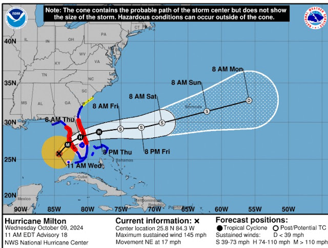
| Source: nhc.noaa.gov. |
So here is the morning track update. There hasn't been much change over the past day or so. Still looks like Milton will pass over somewhere around Melborne or that area as a hurricane.
I hope you've done your preparations. Get your metal detector, batteries and equipment charged. You might lose power at some point.
 |
| Source: windyty.com. |
The ECMWF model on Windyty.com. (shown above) shows the center of Milton making landfall around Tampa/St Pete late Wednesday or very early Thursday, crossing the state and heading out over the Atlantic sometime Thursday afternoon. The clipping above shows Milton out into the Atlantic by 11 PM Thursday. The other models show some difference in timing and track.
AS you can see above, when Milton heads back out into the Atlantic, the wind will be coming from the north on Friday, which will send us a bigger surf. You can see that below. I'd expect some good erosion after Milton passes us.
 |
| Source: surfguru.com. |
Thursday is supposed to produce a four-to-six-foot surf, while Fridays' surf will be up to eight or ten feet.
I wouldn't be surprised if they close some of the beaches again.
Let me know if you see beach closures.
Good hunting,
Treasureguide@comcast.net
---
Shipping container crushed like a soda can in North Carolina floods | Flipboard
