Written by the TreasureGuide for the exclusive use of the Treasure Beaches Report.
 |
| Unidentified Object Dug From Wreck Beach Wednesday. |
Just got this one cleaned up. I need to inspect it closer for markings. No threads or any markings noticed so far. It is hollow and open at both ends. It is a copper alloy.
---
 |
| Turtle Trail About Two Hours Before High Tide Wednesday. |
 |
| Turtle Trail About Two Hours Before High Tide Wednesday. |
 |
| Square Metal Object That Was Visible Last Year Reappeared Yesterday South of Seagrap Trail Access. |
Thanks to DJ for those photos.
DJ also provided the following important information concerning upcoming beach renourishment projects.
Turtle Trail to Golden Sands is scheduled for January to March next year. County engineering says 307,000 cubic yards of beach compatible sand willcome from Stewart Materials in Fort Pierce.
Here are a few more comments on that from DJ.
During 2021-2022 a large sand renourishment project will close some ‘go-to’ treasure beaches in the project areas during the ‘best’ detecting months of Jan-March and November -January over the next two years.
Sector locations are described below and in the map link and plans.
A portion of the sand will be placed from private property (dunes) and seaward to include ‘hard bottom’ area in water although the county does not want to cover ‘hard bottom’ areas as the DEP mitigation costs would be $500,00 per acre. . See page EA page 23 and 2019 plan page 26
The county and FDEP (Florida Department of Environmental Protection) consider all our beaches to be ‘critically eroded’. 15.7 mi of Indian River County’s 22.4 mi shoreline is designated as “ critically eroded” by FDEP.
In the plan linked below are strange comments like this one indicating loss has gone down - but they are still going forward with renourishment (The Countywide annualized shoreline change, from 2013 to 2019, was 0.3 ft/yr, which is less than that of any of the previous time periods)
Beach scraping, (p38 in INDIAN RIVER COUNTY BEACH PRESERVATION PLAN UPDATE 2019 includes a good diagram) is just moving mid beach sand up toward the dunes (to mimic natural beach restoration) and was used in prior years but the new plan recommends against it.
————————Detail links and Resources——————————
This 2019 county update sand plan (copy here: https://www.ircgov.com/departments/public_works/coastal_engineering_section/Documents/2019_IRC_BPP.pdf ) has disturbing details. Details like costing $28 million over the two years, moving 90,000 cubic yards per year from the inlet to cover north county beaches, ‘hard bottom’ areas that the county wants to cover with sand as part of ‘public safety’ and finally the plan includes covering the dunes in some areas.
Page 58 details plan by sector:
2021 Sector 1 and 2 are just south of Sebastian Inlet to Ambersands Beach access. Last year 450,000 cubic yards were taken from the Inlet ‘sand trap’ and placed on these two sectors, inlet to south of Mclarty. Every year 90,000 cu/yds to be added to this area per 2019 updated plan.
This year, 2021, Ambersands will close Jan 4th to Jan 8th.
2021 Sector 3 South of Ambersands to South of Turtle Trail
Jan 1-April 30, 2021 to Wabasso
November to ? 2021 Wabasso to Turtle Trail
470,000 cu yds Per Sector 3 EA plan.
Sector 4 south of Turtle Trail almost to Tracking station
Highest annual loss of 1.7 feet per year. No current plans
Sector 5 Tracking station beach south to Riomar
Was renourished in 2020 155,000 cyds.
Sector 6 South beach south to Sandy Point
No action recommended since beach accretes. No current plans.
Possibly 2021 Sector 7 Sandy Point area Waiting on easement releases from property owners. County only has 50% easement releases so this will be held up for a while. 470,000 cu yds per Sector 7 EA plan.
Sector 8 Galleon Drive (private access in Moorings) south to include Round Island park.
Natural sand accretion (almost 4 feet per year) so no current plans to add sand.
See the sectors on the county map (link https://ircgis.maps.arcgis.com/apps/webappviewer/index.html?id=516bf562edfa49ab863106a2dac3b673) All sectors are listed for Indian River County. Three sectors comprise the project beginning Jan 4 at Treasure Shores.
Interesting to note 19 property owners have refused to sign easement release docs that legally prevent sand being brought in on or in front of their property line.
Thanks for all of that DJ.
Are your elected officials serving you well? Let them know what you think.
---
We have a more southerly wind today with decreasing surf.
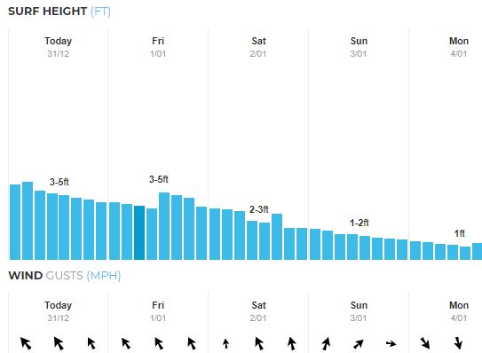 |
| Source: MagicSeaWeed.com. |
Happy New Year!
May your beaches not be all sanded in.
TreasureGuide@comcast.net